![]()
![]()
![]()
Use LEFT and RIGHT arrow keys to navigate between flashcards;
Use UP and DOWN arrow keys to flip the card;
H to show hint;
A reads text to speech;
87 Cards in this Set
- Front
- Back
|
What are the 5 key characteristics of a river? |
- Width |
|
|
Define Width: |
the distance from one bank to the other (rivers get wider downstream) |
|
|
Define Depth: |
the distance from the surface of the water to the bed (rivers get deeper downstream) |
|
|
Define Velocity: |
how fast the water is flowing (flows faster further downstream) |
|
|
Define Discharge: |
the volume of water moving through the river channel in any given time (lower volumes at the upper course) |
|
|
Define Gradient: |
the steepness of the river bed (steeper nearer the upper course) |
|
|
What are the 4 main types of erosion in rivers? |
- Hydraulic Action |
|
|
Describe Hydraulic Action: |
- the force and pressure of water weakens the banks of the river and erodes the rock |
|
|
Describe Abrasion: |
- water pushes rocks along the sides and bottom of the river - like sandpaper - so erodes it |
|
|
Describe Attrition: |
- water causes rocks to hit each other which creates smaller rocks |
|
|
Describe Solution: |
- chemicals in water dissolve the rock |
|
|
What is Transportation? |
- rivers use the energy of the water to transport material such as sand and pebbles |
|
|
What are the 4 main types of Transportation? |
- Traction |
|
|
Describe Traction: |
- the energy of the river rolls large rocks and boulders along the river bed |
|
|
Describe Suspension: |
- small fine particles such as clay and silt are transported by the flow of the river |
|
|
Describe Saltation: |
- it is the transportation of small rocks and pebbles |
|
|
Describe Solution: |
- sodium and calcium etc. have been dissolved by by acids in water and carried in solution |
|
|
What is Deposition? |
- the river drops its load because of less energy and velocity |
|
|
What is a Drainage Basin? |
- the area that is drained by a river and its tributaries |
|
|
What are the source and mouth of a river? |
- source - the beginning of a river (often found in mountains) |
|
|
What is a confluence, tributary and watershed? |
- a confluence is where a tributary meets a river - the point at which two rivers meet |
|
|
What are the characteristics and features of the Upper course of a river? |

Characteristics: |
|
|
What are the characteristics and features of the Middle course of a river? |
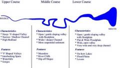
Characteristics: |
|
|
What are the characteristics and features of the Lower course of a river? |

Characteristics: |
|
|
What does the long profile of a river look like? |

See diagram above: |
|
|
Describe how the landform of Interlocking Spurs is formed and which part of the river it is found in: |
- They are an Upper Course Landform |
|
|
Describe how the landform of Waterfalls is formed and which part of the river it is found in: |
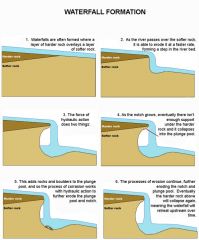
- Upper Course landform |
|
|
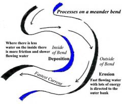
Describe how a Meander is formed and what part of the river it is in: |
- Middle Course Landform |
|
|
Describe how an Ox-bow lake is formed and what part of the river it is found in: |
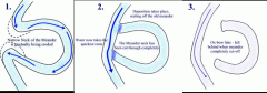
- Middle Course landform |
|
|
What is the thalweg, pointbar and rivercliff? |
- the thalweg is the fastest point in the river |
|
|
Describe how flood plains and what part of the river they are found in: |
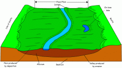
- the floodplain is formed by both erosion and deposition |
|
|
Describe how levees are formed and what part of the river they are found in: |
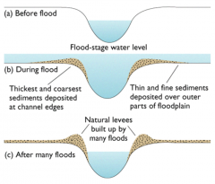
- in times of floods, water and sediment come out of the channel as the river overflows its bank |
|
|
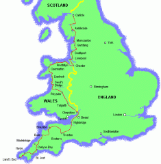
Describe where the Afon Nant Peris river is and what surrounds it at its different parts: |
- in Wales |
|
|
Describe the characteristics of the Afon Nant Peris river at its different sections: |
- at the source (pen-y pass) it is a narrow valley with mainly vertical erosion |
|
|
Give a statistic of the area of which the river Afon Nant Peris is in: |
- this whole area receives 2500mm of rain each year and 80% flows out along the river |
|
|
Give 12 physical causes of flooding: |
- heavy rainfall in an area with little vegetation |
|
|
Give 6 human causes of flooding: |
- a flood control dam being opened in a country upstream |
|
|
Describe the characteristics of a forested slope: |
- there is a layer of saturated rock with a groundwater table on top - this helps preserve a high water table and there is slow movement of water through the drainage basin |
|
|
Describe the characteristics of a deforested slope: |
- on a deforested slope there is more flooding |
|
|
What are the characteristics of an area before urbanisation? |
- precipitation is intercepted by the tops of trees |
|
|
What are the characteristics after urbasnisation? |
- less vegetation so less interception |
|
|
Describe what a hydrograph shows and where: |
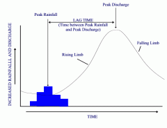
- y-axis - increased rainfall and discharge |
|
|
What does a hydrograph show? |
shows how a river responds to a period of rainfall |
|
|
What were the 3 main causes of the Carlisle floods and when were the Carlisle floods? |
- January 2005 |
|
|
What were the 3 main effects of the Carlisle floods? |
- 3 people died - 2 from drowning and 1 from a falling wall |
|
|
What were the 3 main responses to the Carlisle floods? |
- installing a pumping station |
|
|
What were the 4 main causes of the Sheffield floods, where is Sheffield and when were the floods? |
- 2007 |
|
|
What were the 4 main effects of the Sheffield floods? |
- 2 people drowned |
|
|
What were the 3 main responses to the Sheffield floods? |
- Meadowhall Shopping Centre has its own defences - an embankment around it to hold off water |
|
|
What are the 4 ways that governments try to prevent flooding? |
forecasting, building design, planning and education |
|
|
How do governments prevent flooding by forecasting? |
rivers with a history of flooding are monitored by the environment agency |
|
|
How does building design prevent flooding? |
ceramic tiles are put on floors as they are impermeable |
|
|
How is flooding prevented by planning? |
now in at risk areas buildings have to have sufficient protection measures against floods |
|
|
How does education help to prevent flooding? |
governments educate the local people about prevention and recovery |
|
|
What are the six ways to manage floods? |
flood walls, channel straightening, flood relief channel, embankments, deepening the river, dams |
|
|
How do flood walls manage floods? |
built around factories - made out of concrete |
|
|
How does channel straightening manage floods? |
straightens the river channel so water can run through more quickly |
|
|
How do flood relief channels manage flooding? |
digs extra channels on the river to divert it |
|
|
How do embankments manage flooding? |
they raise the heights of riverbanks and aim to stop water spreading to other areas |
|
|
How does deepening the river manage flooding? |
the river is deepened to store more water to increase its flow |
|
|
How do dams manage flooding? |
they can trap and store water to control flow and are built upstream to regulate flow |
|
|
What are the 4 types of soft engineering methods? |
washlands, afforestation, land use zoning and flood warning systems |
|
|
What are the 4 hard engineering methods? |
embankments (levees), channelisation, dams and floof relief channels |
|
|
How do washlands manage flooding? |
these are areas on the flood plain that are allowed to flood which gives a safe place for floodwater to go, it is also cheap and leaves the natural environment unspoilt, however the flood plain can't be used for other things |
|
|
How does afforestation manage flooding? |
- trees are planted in the drainage basin as trees intercept rainfall and take water out of the soil which reduces the amount reaching rivers - wooded areas look attractive and provide wildlife habitats but then land then can't be used for other activities, such as farming |
|
|
How does land use zoning manage flooding? |
- governments allocate areas of land to different uses, according to their level of flood risk - major building projects are allocated to low risk areas - open space for leisure and recreation is placed in high-risk areas because flooding would be less costly for them - these may not be the best places in terms of public accessibility |
|
|
How do flood warning systems manage flooding? |
- rivers are carefully watched and if the levels are rising, places downstream can be warned - people living in towns or villages downstream have a chance to prepare or evacuate - sometimes it isn't possible to give very much warning and so it is hard to save possessions |
|
|
Describe the case study of the River Skerne,how it tried to prevent flooding and how successful it was: |
- in Darlington, and flooded in June 2007 - in the 19th century the meanders were straightened to allow industries to build on the flood plain, though this decreased its length by 13% which increased the flood risk - the Environment Agency restored 2km or river - some meanders were rebuilt, lengthening the river and slowing water down - banks were lowered to make the river flood the park instead of Darlington - the flood plain was lowered to increase its ability to store floodwater - it did flood in 2007, but rainfall was high so despite the damage it was better than the floods in 2000, which was before the work was done - 50 homes were flooded due to the backlog of rainwater entering the city's drains - there was a large increase in species with a 30% increase in birds and insects, within one year - locals liked the changes - in a survey 82% of people liked it either 'mostly' or 'strongly' |
|
|
Name the soft engineering case study and its location: |
- on the River Skerne - near Darlington |
|
|
What is the background information on the Soft Engineering River Skerne case study? |
- on River Skerne, NE England - river meandered across a flood plain, but over the 200 years before 1998 the river was straightened and deepened - flood plain used as a tip for industrial waste - was a straight urban drain - carried flood waters through a built-up area |
|
|
What was done on the River Skerne, using soft engineering to prevent flooding? |
- from 1998 was restored to its natural meandering by using earthmoving equipment to create large bends which enables the river to flow from side to side and for water to run off on to the flood plain during floods - wide range of wetland habitats created alongside the river - banks of meanders protected with coconut fibre rolls and willow stakes to prevent excessive erosion until tree roots become established - over 20,000m cubed of industrial spoil was removed from the flood plain so the river can overflow its banks but still protect surrounding housing - spoil used to reshape and raise the valley sides - 20,000 trees and shrubs planted, as well as wildflowers and bulbs, improving water quality, reducing flooding and increasing wildlife such as swans, fish, dragonfly and water voles |
|
|
What were the benefits of using soft engineering on the River Skerne? |
- cheaper - more environmentally friendly way of protecting houses and buildings in the area rather than traditional hard engineering methods |
|
|
Name the hard engineering case study, its location and its background information: |
- Hard Engineering in York - York - prone to flooding by River Ouse and Foss |
|
|
What has been put in place, using hard engineering, to prevent flooding in York? |
- over last 20 years hard engineering was put in place to protect homes and families - mostly raised embankments - some earth, some concrete (supported by steel sheeting) - natural floodplain upstream of York, called Clifton Ings stores 2.3 million cubic litres of water and lowers the city's peak flood level by 150mm - banks around the Ings were raised in 1982 and sluice controls were built for letting flood water in and out of the Ings |
|
|
What were the disadvantages of using hard engineering in York? |
- very expensive - not benefited wildlife - water still overflows the embankments causing damage to homes, offices and factories; happened in 2000 and left the city with a clean-up bill of £1.3 million not including cost of damage to people's homes and businesses |
|
|
What was introduced in York in 2008 and what are they? |
- new system introduced for a trial - temporary hollow plastic barriers called 'Aquabarriers' - have holes in one side, allowing flood water in and increasing flood stability - when the flood recedes, the water drains out or the holes |
|
|
What are the advantages of Aquabarriers? |
- cheaper than traditional hard engineering solutions - can be easily moved |
|
|
What are the characteristics of a hydrograph in a rural area? |
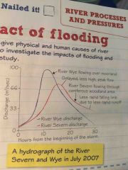
e.g. River Severn - lag time is longer - flows through coniferous woodland which absorbs the water and delays it in reaching the river - peak flow of the river is less high and more delayed - less rapid falling limb due to less rapid runoff |
|
|
What are the characteristics of a hydrograph in an urban area? |
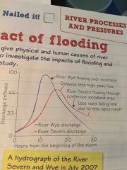
e.g. River Wye - lag time is very short - water runs over moorland which doesn't have much vegetation to absorb it - discharge reaches a higher amount, increasing the risk of flooding |
|
|
What were Sheffield's drains and culverts designed to do and what were their two problems in 2007? |
- they carry away rainwater and were designed to deal with rainfall amounts that might only occur once in 30 years - but the 2007 floods were a 1 in 400 year event and people wonder whether anything could have protected them Problems: - couldn't cope with the rain, so streets flooded - where drains met the rivers, water couldn't escape as the rivers were already high |
|
|
Define Hard Solutions and Soft Solutions: |
Hard - structures built to defend areas from floodwater Soft - adapt to flood risks and allow natural processes to deal with rainwater |
|
|
What 3 things does the UK's Environment Agency believe? |
- hard defences are not the solution - buildings at risk must be flood-proofed (e.g. on raised sites or protected by walls), or companies relocated to safe locations - councils should increase maintenance - streams and drains block easily with debris or tree branches |
|
|
What was most of Sheffield's flooding caused by and what other natural things added to the flooding? |
- drains, river channels and flood defences being overwhelmed by extreme flows of water - sudden downpours of rain made everything happen so quickly and made it difficult to predict where flooding might occur - fallen trees along the rivers Sheaf, Loxley and Don quickly blocked river channels - as surface run-off raced down Sheffield's hills, drains were blocked and overflowed |
|
|
What were the impacts of Sheffield's floods on Hillsborough and North-West Sheffield? |
- Hillsborough Football Stadium was flooded up to 8 metres deep and it cost several million pounds to repair the damage - of 300 homes on on estate, 128 (43%) were flooded and though all council tenants returned home within 9 months some owner-occupiers had to wait much longer as builders were so inundated with work - displaced people suffered stress and some families were moved into caravans for the winter - there were several health risks from raw sewage escaping into floodwater |
|
|
What were the impacts of Sheffield's floods on the city centre and the River Don floodplain? |
- in the city centre on 25th June, motorists had to abandon their vehicles as roads flooded and traffic gridlocked - as floodwaters rose, many people were caught unaware and had to be evacuated from flooded buildings - so many trains and buses were cancelled that many people were unable to get home and some were trapped overnight, with over 900 people spending the night in their offices - 20 people were airlifted to safety from one building and a further 3 from the roof of another - 200 people were stranded on the first floor of a Royal Mail distribution centre |
|
|
What were the impacts of Sheffield's floods on the Lower Don Valley? |
- deepest flooding occurred in areas near the River Don, where some industries were badly affected - the tool-making company Clark-Osborn suffered £15 million in flood damage with equal damage to Sheffield Forgemasters International and Cadbury Trebor Bassett - Meadowhall shopping centre was flooded causing millions of pounds work of stock losses and damage and closing the centre for a week; its flood defences, built to withstand a '1 in 100-years' flood event, were overwhelmed |
|
|
What were the impacts of Sheffield's floods on the Ulley Reservoir Area? |
- on 26th June, there were fears that the Ulley dam might collapse, following the rains and damage to its structure - 700 residents were evacuated from the villages of Whiston, Canklow, Catcliffe and Treeton with some being allowed back 2 days later but some being allowed back 2 weeks later - 100 people took shelter at Dinnington Comprehensive School, where the Salvation Army provided clothes, food and bedding - about 100 people had to be rehoused for up to a year where flood damage was severe - the M1 motorway was closed for 2 days between junctions 32 and 36 because of the risk of the dam bursting |