![]()
![]()
![]()
Use LEFT and RIGHT arrow keys to navigate between flashcards;
Use UP and DOWN arrow keys to flip the card;
H to show hint;
A reads text to speech;
60 Cards in this Set
- Front
- Back
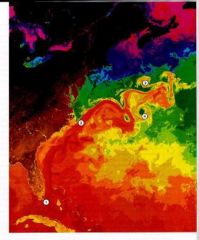
The figure below shows water temperatures off the eastern side of the continental United States. Red indicates warm water while blue indicates cold water. What is the number 3 showing? |
A warm core eddy |
|
|
Generally the fastest and deepest ocean currents are
|
western boundary currents.
|
|
|
A large clockwise spinning circulation of air in the northern hemisphere would produce what type of ocean flow?
|
A converging water mass towards the center of the air circulation.
|
|
|
In the northern hemisphere, in what direction is the "net" theoretical flow of water with respect to the prevailing wind direction?
|
90 degrees to the right of the winds |
|
Winds blowing from the south along the eastern side of Florida would produce
|
upwelled, cooler, more nutrient-rich waters.
|
|
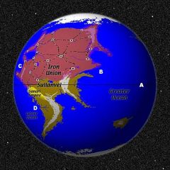
The world shown below is made-up. Assuming this world spins opposite to that of the Earth, in what direction would you expect the ocean currents to flow at point B?
|
Flowing to the south
|
|
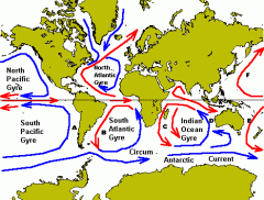
Match the letters on the map to the corresponding ocean current.
|
A – Peru Current, B – Brazil Current, C – Algulhas Current, D – Western Australian Current, E – Eastern Australian Current, F – Kuroshio Curren
|
|
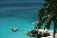
Bimini, Bahamas is approximately 50 miles due east of Miami. If you leave Miami in your power boat heading to Bimini and the engine dies 2 miles off shore, where would you end up?
|
Ocean currents will bring you north of Miami |
|
|
Britain's weather is _____________________ than would be expected at that latitude because of the influence of surface currents
|
warmer
|
|
|
Which ocean surface current carries the greatest volume of water?
|
The West Wind Drift
|
|
|
What atmospheric signal relays the arrival or departure of an El Niño event?
|
Southern oscillation
|
|
|
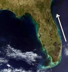
The arrow in the figure below is indicating warmer than usual waters in the red-colored region. What is this figure showing?
|
An El Niño event
|
|
|
The main force driving the thermohaline circulation is
|
gravity.
|
|
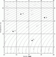
Four layers of ocean water, denoted by the letters A-D in the diagram below are situated in an ocean profile. List how the layers are arranged from TOP to BOTTOM. The units for density in the diagram are sigma-t.
|
Layer one (top) – A, Layer two – C, Layer three – B, Layer four (bottom) – D
|
|
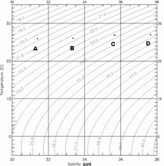
Four layers of ocean water, denoted by the letters A-D in the diagram below are situated in an ocean profile. List how the layers are arranged from TOP to BOTTOM. The units for density in the diagram are sigma-t.
|
Layer one (top) – A, Layer two – B, Layer three – C, Layer four (bottom) – D
|
|
|
Which of the following would decrease the density of seawater?
|
Increase temperature
|
|
|
1 million cubic meters of ocean water flow per second is also referred to as a
|
Sverdrup
|
|
|
The Cromwell Current is
|
a shallow current below a surface current and flowing in the opposite direction.
|
|
|
Countercurrents and undercurrents generally move _____________ than the surface current above, and in ______________ direction.
|
slower ... the opposite |
|
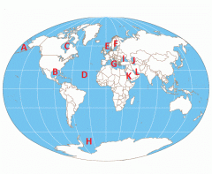
Match the following bodies of water shown below with the appropriate name:
|
A – Bering Sea, B – Gulf of Mexico, C – Hudson Bay, D – Atlantic Ocean, E – North Sea, F – Baltic Sea, G – Mediterranean Sea, H – Weddell Sea, I – Black Sea, J – Caspian Sea, K – Red Sea, L – Persian Gulf
|
|
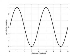
The wave shown above has a wavelength of __________ meter(s) and a wave height of __________ meter(s). |
(no answer) |
|
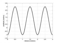
The wave shown above has a wavelength of _________ meter(s) and a wave height of ___________ meter(s).
|
(no answer) |
|
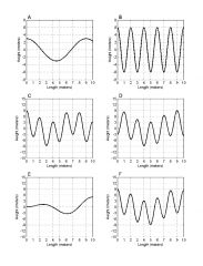
If waves A and B meet, what will be the resulting wave pattern? |
F |
|
|
The horizontal distance measured from trough to trough (or crest to crest) of a wave is the
|
wavelength.
|
|
|
The number of peaks to move past a stationary position within one second refers to the wave's
|
frequency
|
|
|
Refraction of shallow-water waves is generally due to
|
the varying speed of the wave due to the differences in depth.
|
|
|
Which of the following statements regarding Tsunamis is TRUE?
|
Tsunamis have an extremely large wavelength
|
|
|
Which of the following statements regarding "Rogue Waves" is TRUE?
|
Rogue waves generally last for only a short period of time
|
|
|
What is the first sign of an approaching tsunami?
|
Lowering sea levels
|
|
|
A wave traveling across the ocean has a wavelength of 1000 feet and is traveling in a water depth of 200 feet. What will influence how fast this wave moves?
|
The depth of the water the wave is traveling through
|
|
|
A wave traveling across the ocean has a wavelength of 10 feet and is traveling in a water depth of 2000 feet. What will influence how fast this wave moves?
|
The wave's own wavelength
|
|
|
Which of the following statements regarding Internal Waves is TRUE?
|
Internal waves move relatively slowly
|
|
|
Near shore, if the wave crests are two hundred feet apart, the wave will "feel" bottom when the depth is about
|
100 feet
|
|
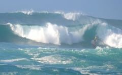
What causes the waves in Hawaii to get so big? |
Storms near the Aleutian Islands to the north blow for over 2 days
|
|
|
The first waves to form on the ocean surface when the wind starts to blow are |
capillary waves.
|
|
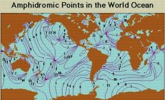
An amphidromic point is
|
A "no tide" point in the ocean around which the tide crest rotates through one tidal cycle
|
|
|
The tides at any one locality will result from the interaction of which of the following major contributors? (There can be ANY number of answers and there is negative scoring for guesses)
|
The Sun's position, The Moon's position, Local land configuration
|
|
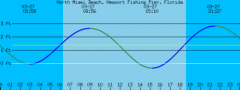
The following is a tide table for North Miami Beach on March 27, 2005. From the times below pick which ones correspond to a condition of "Slack Water." (There areANY number of answers and negative scoring for guesses)
|
The correct answer is: 2:58, 8:56, 15:10, 21:27
|
|
|
The tides at any one locality will result from the interaction of
|
All of these things.
|
|
|
A tide pattern with two high tides (one much higher than the other) and two low tides (one much lower than the other) each day is called a
|
mixed tide.
|
|
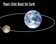
The side of the Earth facing the moon will experience a high tide, while the opposite side of the Earth will likely have a
|
high tide.
|
|
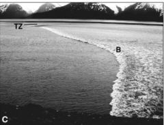
Tidal bores (shown as 'B' in figure below) usually occur
|
in rivers or long narrow bays.
|
|
|
Which of the following would produce the highest tides?
|
Spring tide
|
|
What type of tides would be expected during a Full Moon?
|
Spring tides where the high tide will be much higher
|
|
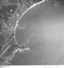
These artificial constructions extending from the beach are designed to limit longshore drift. What are they?
|
Thegroin
|
|
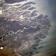
Where the Indus river flows into the Arabian Sea (see below), the sediment at the river's mouth piles up to form a
|
delta
|
|
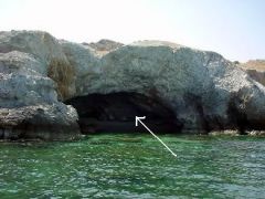
The darker region shown inside the land (eroded due to wave action) is called a
|
sea cave
|
|
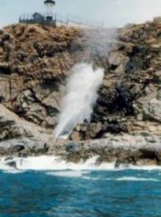
The water being forced upwards within the rocks is also called a
|
blowhole
|
|
|
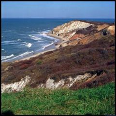
The origin of sea cliffs, sea stacks, sea caves, blowholes, and arches is related to
|
erosion by waves
|
|
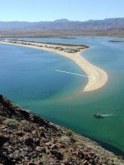
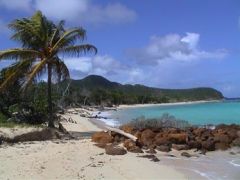
The geological feature shown in this picture represents what?
|
A sand spit
|
|
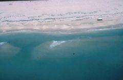
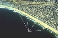
The darker region of water represents a narrow channel of water quickly returning to the open ocean. What is another name for this?
|
Rip current
|
|
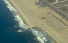
The figure below shows manmade objects that extend from the beach and help to minimize erosion that reduce the size of the beaches. What are these manmade objects called?
|
Groins
|
|
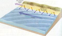
The figure below shows sand moving up the coast in a zigzag pattern. What is the name for this transport of material?
|
Longshore drift
|
|
|
The refraction of ocean waves near a coastline tends to
|
erode those portions that are protruding out from the mainland.
|
|
A long-term effect of wave refraction is
|
to straighten a coast.
|
|
|
If a beach is wide, gently sloping with fine sands, we would expect to see
|
generally smaller waves in the winter and summer.
|
|
|
Oceanographers usually classify coasts by
|
the physical processes shaping the coasts.
|
|
Most of the minerals found in the sand of continental beaches are supplied by
|
rivers and streams.
|
|
|
Estuaries can be created by
|
retreating glaciers.
|
|
Most of today's Martha's Vineyard represents what?
|
The location of the furthest advance of the last glaciers
|