Reading...
![]()
Play button
![]()
Play button
![]()
Use LEFT and RIGHT arrow keys to navigate between flashcards;
Use UP and DOWN arrow keys to flip the card;
H to show hint;
A reads text to speech;
297 Cards in this Set
- Front
- Back
|
What are the differences between hydrosphere, cryosphere atmosphere, geosphere, lithosphere and biosphere?
|
Hydrosphere: includes water in solid liquid, and gas forms
Cryosphere: the frozen part of the hydrosphere Atmosphere: gasses and suspended particles surrounding the planet Geosphere: Solid - rocks, minerals and sediments Lithosphere: composed of uppermost mantle and crust divided into riged plates that move and interact Biosphere: all living organisms |
|
|
What % of the earths surface is covered by oceans?
|
71%
|
|
|
What are the two most abundant gasses in the atmosphere and the percentage by each volume?
|
Nitrogen at 78%
oxygen at 21% |
|
|
The interior of the earths four layers are
|
Inner Core - solid
Outer core - liquid Mantle - solid Crust - solid |
|
|
How do we know about the four layers of the earth surface?
|
from seismic waves (earthquakes)
|
|
|
What is the lithosphere and which part of the earths four layers compose the lithosphere?
|
•
• uppermost mantle and crust |
|
|
The difference between inner core and outer core?
|
• inner core is solid
• outer core is liquid |
|
|
What is the difference between weathering and erosion
|
• weathering: physical or chemical breakdown of rocks
• erosion is: removal and transportation of rock fragments by running water, ice, or landslides |
|
|
Describe global water cycle in terms of evaporation, transpiration, sublimination, condensation, precipitation, deposition, run-off, and infiltration
|
• evaporation: water - liquid to gas
• transpiration: water - vapor released by plants into atmosphere • sublimination: water - solid to gas • condensation: water - gas to liquid • precipitation: water - rain or snow • deposition: water gas to solid • run-off: water - flowing on surface of earth • infiltration: surface of earth into the ground |
|
|
In which of Earth’s 4 spheres (Earth System) do the parts of the Global Water Cycle take place?
|
• Evaporation - hydrosphere to atmosphere
• Sublimation - hydrosphere to atmosphere • transpiration - biosphere to atmosphere • condensation - atmosphere to hydrosphere • precipitation - atmosphere to hydrosphere • Infiltration - hydrosphere to geosphere • runoff - hydrosphere |
|
|
In which of Earth’s 4 spheres does evaporation take place?
|
hydrosphere to atmosphere
|
|
|
In which of Earth’s 4 spheres does sublimation take place?
|
hydrosphere to atmosphere
|
|
|
In which of Earth’s 4 spheres does condensation take place?
|
hydrosphere and atmosphere
|
|
|
In which of Earth’s 4 spheres does deposition take place?
|
atmosphere and hydrosphere
|
|
|
Which spheres are involved in infiltration?
|
hydrosphere and geosphere - because it goes into the ground
|
|
|
Which is older, continental or oceanic crust?
|
Continental Crust
|
|
|
Which is denser- continental or oceanic crust?
|
Oceanic crust - tt will always move under the continental crust
|
|
|
How does is the continental shelf, slope, and rise differ between tectonically active and tectonically passive continental margins?
|
• Active - narrow continental shelf, steep continental slope, trench instead of continental rise
• Passive - wide, flat continental shelf, gentle continental slope, continental rise |
|
|
In which ocean (Atlantic or Pacific) are there more Abyssal Plains? In which ocean are there more trenches? Why?
|
There are more abyssal plains in the Atlantic because in the Pacific the trenches trap the sediment as it comes off shore. The sediment gets stuck in the trenches and does not reach the open ocean basin floor and thus does not have the opportunity to create abyssal plains.
|
|
|
How does an atoll form?
|
• Step 1: Volcano forms. Reef begins to grow in shallow water on flanks of volcano.
• Step 2: Volcano is extinct and begins to erode. A shallow lagoon separates the volcano from the reef. • Step 3: Volcano erodes below sea level. The reef may grow until it eventually breaks above the surface. |
|
|
What happens to age of the ocean floor as you move away from the axis of a ridge?
|
Age of the floor increases
|
|
|
What happens to water depth?
|
Depth increases
|
|
|
What happens to heat flow from the mantle?
|
Heat flow increases
|
|
|
What would happen to the circumference of the Earth if there was subduction, but not sea-floor spreading?
|
If there was subduction, but not sea-floor spreading, the Earth would get smaller.
|
|
|
What would happen if there was sea-floor spreading but not subduction?
|
the Earth would get larger
|
|
|
Which part of the seafloor is older, the middle or the near the coast?
|
The oldest seafloor is near the coast.
|
|
|
How do magnetic anomalies support plate tectonics and seafloor spreading?
|
Magnetic anomalies record the movement of the plates, the age of the rocks, and the magnetic reversals. They can be used to track the movement
of the plates over the past. |
|
|
What are the plates made of?
|
Lithosphere
|
|
|
What is the driving force of movement?
|
Convection
|
|
|
Are there earthquakes at divergent plate boundaries? Is there volcanic activity?
|
• Yes
• Yes |
|
|
Are there earthquakes and volcanoes at oceanic-oceanic convergent plate boundaries?
|
• Yes
• Yes |
|
|
In an Oceanic-Continental Convergent plate boundary, which plate is denser? Why is it denser?
|
Oceanic is denser because of the amount of iron and magnesium
|
|
|
Are there volcanoes and earthquakes at oceanic-continental convergent plate boundaries?
|
• Yes
• Yes |
|
|
Are there earthquakes at continental-continental convergent plate boundaries?
|
Yes
|
|
|
Are there earthquakes at Transform Plate Boundaries?
|
Yes
|
|
|
Which Plate Boundaries have earthquakes??
|
All of Them
|
|
|
Which Plate Boundaries have volcanic activity?
|
Divergent, Oceanic-Oceanic convergent, Oceanic-Continental convergent
|
|
|
Which direction is the Pacific Plate moving?
|
The Pacific Plate is moving towards the North-west.
|
|
|
Which of the Hawaiian Islands is the oldest?
|
Kauai
|
|
|
Which is the Youngest?
|
The big island of “Hawaii” is the youngest.
|
|
|
Which is closest to the hot spot?
|
The big island of “Hawaii” is closest to the Hot Spot
|
|
|
Which plate boundary is closest to Utah going East?
|
Mid-Atlantic Ridge
|
|
|
Which plate boundary is closest to Utah going West?
|
The San Andreas Fault
|
|
|
Why is the polarity of water important?
|
Because water is polar, it has a net positive charge on one side and a net negative charge on the other side. This allows water molecules to bond via hydrogen bonding to other water molecules. It also allows other substances like sodium to dissolve easily in water.
|
|
|
Compare the temperature range between the two cities. Why is the range so much greater inland that it is near the coast? What can you say about the temperature range of city on the coast versus a city inland?
|
• Because water absorbs heat without changing temperature, the city on the coast does not get as hot in the summer. In the winter, the city near the coast uses the heat absorbed by the water in the summer to keep warm, thus it does not get as cold.
• The city inland is much hotter in the summer and much colder in the winter. |
|
|
Why is Edmonton colder in the winter and warmer in the summer?
|
Edmonton is inland. It does not have the ocean to keep it warm in the winter and cool in the summer. Juneau is on the coast. The ocean absorbs a lot of energy during the summer, then releases that energy in the winter, keeping Juneau warm. It absorbs all the energy in the summer, which keeps Juneau cool.
|
|
|
Why is most of the ocean light blue (no difference between the temperature during the day and the temperature at night)?
|
• There is no difference between the day and night temperature of the ocean because during the day, the ocean absorbs energy from the
sun, keeping the day cooler. • During the night, the ocean releases the energy it absorbed during the day, keeping the night warmer. |
|
|
To increase salinity, would you melt or form sea ice?
|
Form sea ice
|
|
|
What about decreasing salinity?
|
melt sea ice
|
|
|
Would precipitation over the oceans increase or decrease salinity?
|
Precipitation decreases salinity
|
|
|
Does evaporation increase or decrease salinity?
|
Evaporation increases salinity
|
|
|
What is the pressure if the depth is equal to 3500 m?
|
350 kg/cm2
|
|
|
What is the depth if the pressure is equal to 24.5 kg/cm3?
|
245 m
|
|
|
Where will there be the greatest accumulation of lithogeneous sediments?
|
Closest to the continents
|
|
|
Clay sized sediment from the Sahara Desert has been found in the Caribbean. How did it get there?
|
May have been transported by wind or ocean currents.
|
|
|
What is methane hydrate?
|
A solid form of methane bonded with water
|
|
|
Where are methane hydrate deposits located?
|
Continental shelf and slope deposits
|
|
|
Why is methane hydrate important?
|
It can be used as an energy source for the future
|
|
|
How can calcareous oozes be found at depths greater than 4500 m?
|
Calcareous oozes can be found at depths greater than 4500 m if they are buried by another type of sediment before being moved (via plate tectonics) to deeper water.
|
|
|
Continental Crust
|
• Type of crust that is thick
• Composed mostly of granite, rich in silicon and aluminum, • Has a low density but is thicker |
|
|
Specific Heat
|
The amount of heat that will raise a gram of saple of a substance by 1 degree C
|
|
|
Hot Spot
|
Forms when a plate moves over a mantle plume (NOT a plate boundary)
|
|
|
Geostationary
|
A type of satellite that remains over a fixed point of the Earth.
|
|
|
Neriic Deposits
|
Near Shore Lithogeneous deposits
|
|
|
Hydrogeneous sediment
|
Sediment that is precipitated from water
|
|
|
Lithogeneous sediment
|
Sediment from weather and erosion of continents
|
|
|
Coral Atoll (in French Polynesia)
|
Rin shaped island surrounding a lagoon, formed on eroding volcano
|
|
|
Pangaea
|
Name of the super Continent proposed by Alfred Wegener
|
|
|
Foraminifera and Cocolithophre
|
Are both organisms that make up calcareous ooze
|
|
|
Polar orbiting satellite
|
Satellite that orbits the outer poles
|
|
|
Biogeneous sediment
|
Sediment that has its source from life, once dead organisms, bones, etc
|
|
|
Oceanic Crust
|
Part of the earth that is solid, and very dense
|
|
|
Transform Plate Boundary
|
The type of boundary hwere two plates slide past eachother
|
|
|
Calcereous Oozes
|
• Water shallower than 4500 m
• Make shells out of CaCO3 (calcium carbonate) • Foraminifera - single cells • Cocolithopher - single celled algae, photosynthetic |
|
|
Convection
|
mechanism for plate movement
|
|
|
Evaporation
|
• Liquid water that changes into water vapor without boiling
|
|
|
Divergent Plate Boundary
|
Type of plate boundary where plates move away from each other
|
|
|
Biosphere
|
Part of Earth that is made up of living organisms
|
|
|
Cosmogeneous sediment
|
Marine sediment from space
|
|
|
Convergent plate Boundary
|
The type of plate boundary where plates collide
|
|
|
Covalent Bond
|
Type of bond holding one water molecule to another water molecule
|
|
|
Cryosphere
|
Frozen part of the hydrosphere
|
|
|
Two examples of a continental-continental convergent plate boundary
|
• Himalayas
• St. Andreas Fault |
|
|
Cosmogeneous sediment
|
• Comes from space
• Meteorites: small % of seafloor sediments, infrequent burns up in atmosphere • Space dust: micro-filaments that fall through atmosphere • Tektites a form of rock that is melted or has melted when hit by a meteorite |
|
|
Tektites are
|
• A form of rock that is melted or has melted when hit by a meteorite.
• A form of Cosmogeneous sediment |
|
|
Submarine Canyons
|
These are cared into continental slope by turbidity currents
|
|
|
Type of crust that is thin, composed of basalt, rich in iron and magnesium and is very dense
|
Oceanic Crust
|
|
|
Hydrosphere
|
Part of the earth that includes water as a solid, liquid, and gaseous forms
|
|
|
Atmosphere
|
Gases and suspended particles surrounding the planet
|
|
|
Flat, very flat areas of the seafloor
|
Abyssal Plains
|
|
|
Divergent
|
Plates move away from eachother
|
|
|
Hydrothermal Vents
|
underwater hot springs
|
|
|
Pillow Basalts
|
pillow shaped rocks, formed from lava flow under the water
|
|
|
Taypes of Water Changes
|
Evaporation -
Sublimation Transpiration Deposition Infiltration Condesnsation Preicpitation Run0ff |
|
|
Marine Sediment Deposits
|
• Neritic Deposits - Delta and lithogeneous, larger grain size - Near the shore
• Palegic Deposits - Deep ocean basins. Calcareous Oozes - Siliceous oozes • Source for most is in erosion from the continents • Also can be can be considered tectonically passive |
|
|
Neritic Deposits
|
• Delta and Lithogeneous
• Larger grain size • Near the shore |
|
|
Palegic Deposits
|
• Deep ocean basins
• Calcareous Oozes • Siliceous oozes |
|
|
Sediment Deposit (n mid--ocean locations)
|
Sediment thickness
• 5c per 1000 years • .005 er 1,000 years |
|
|
Ice-Rafted Glacial Sediments
|
Occures mostly on the floor of a polar ocean
|
|
|
Deep Sea Muds (Clays)
|
Found primarily in the mid-ocean basins
|
|
|
Submerged River/Valley Submarine Canyons
|
Acts as a conduit to move sediments from the continental shelf to the base of the continental slope
|
|
|
Types of sediment flow/transport
|
Rivers: in tropics great than in higher altitudes, greater sediment input in summer
Streams: sediments are near rivers on earth Basins: Extensive vegetation cover makers sediment flow/transportation |
|
|
Annual Sediment Transport
|
• Greatest average is the Houng Ho River
• All factors equal a. greater sediment input into ocean by rivers is in summers b. tropics transport greater sediment load than a river located at high altitudes |
|
|
Limestone
|
• is resulted from the li of calcareous oozes that was transported from a location closer to the Mid-Atlantic ridge
|
|
|
Calcareous Oooze
|
• 30% calcareous organisms
• found in depths less than 4500 miles • can be found below depth of 4500 miles if they are burried y another type of sediment before being moved • Mid-Atlantic ridge can be found limited as limestone Organisms: - - Foraminifera - single cells - - Cocolithophore - single celled algae, photosynthetic • Dissolves n deep water |
|
|
Lithogeneous Sediment
|
• in continental margins, in principle source is the river discharge and erosion of offshore materials
• are Neritic Deposits • Thickest sediments |
|
|
Carbonate Composition Depth (CCD)
|
The depth of the ocean below which calcium carbonate dissolves and does not accumulate on the ocean floor.
|
|
|
Biogeneous sediments
|
• From living organisms or their remas
- - includes shells bones, coral, skeletal parts - - includes excretions and secretions |
|
|
Siliceous Ooze
|
30% siliceous organisms (distances/radiolarians)
• Can be found at any depth |
|
|
Diatoms
|
Dominant high latitudes ocean locations - single celled algae and photosynthetic
|
|
|
Radiolarians
|
Are in upwelling zones - single celled
|
|
|
Red Clay
|
• Origin of red clay is land
• Dominant in ocean water deeper than 4500 miles. |
|
|
Neritic Deposits
|
• Larger gain size
• near shore - continental margins • Lithogeneous • In Delta and Wetlands |
|
|
Delta
|
• Fan shaped deposit formed when a stream enters the ocean and drops all of its sediment
|
|
|
Wetlands
|
Low lying flat areas. Covered as water at least part of the year.
|
|
|
Calving
|
When a piece of glacier breaks off, forms icebergs
|
|
|
Delta
|
Fan shaped deposit continental rise at the base of the submarine canyon.
|
|
|
Pelagic Deposits
|
• Deep ocean basins
• Calcareous Oozes • Siliceous Oozes |
|
|
Hydrogeneous Sediments
|
Precipitated from seawater
• Ooliths - tiny sphere of calcite • Manganize nodules |
|
|
Manganese Nodules
|
• Black Nodules
• Manganese, iron, copper cobalt, and nickel • Form as coatings |
|
|
Distribution of Biogeneous and Lithogenous Sediments on the seafloor
|
BIOGENEOUS SEDIMENT
• Calcareous • Radiolarians • Diatoms LITHOGENEOUS SEDIMENT • Deep-Sea Muds Terrigeous • Glacial-marine |
|
|
Neritic Deposits
|
• Larger grain size
• Near Shore - contnental margins • Lithogeneous •Delta (where a river enters the ocean) • Wetlands |
|
|
Part of Earth that includes water in solid, liquid, and gaseous forms
|
Hydrosphere
|
|
|
An example of continental-continental convergent plate boundary
|
Himalayas
St Andreas Fault |
|
|
Sediment coming from weather and erosion from the continents
|
Lithogenous Sediment
|
|
|
Sediment precipitated from seawater
|
Hydrogeneous
|
|
|
Example of a hot spot
|
French Pyrenees
|
|
|
Flat, very flat areas of sea floor
|
Abyssal Plane
|
|
|
These organisms make up a Siliceous Ooze
|
• Diatoms
• Radiolarians |
|
|
Exclusive Economic Zones (EEZ)
|
• Extends 200 nautical miles offshore of country
• Or to edge of continental shelf (if further than 200 nautical miles offshore) |
|
|
Oil and Natural Gas
|
• Organicmatter (biogeneous sediments) accumulate in shallow sea
|
|
|
Gas Hydrates
|
• Read 256-258
• Solidformofmethane • Found in sediment on continental shelf and slope |
|
|
How does the atmosphere affect the oceans?
|
The atmosphere and oceans are constantly exchanging H2O through evaporation and precipitation.
|
|
|
How do the oceans affect the atmosphere?
|
The temperature of one
affects the temperature of the other. Wind in the atmosphere affects ocean waves and currents. |
|
|
How does the continental shelf, slope, and rise differ between tectonically active and tectonically passivly continental margins?
|
• Active - Narrow continental shelpf, steep continental slope, trench instead of continental rise.
• Passive - wide, flat continental shelf, gentle continental slope, continental rise |
|
|
Tectonically Active continental margins
|
Active - Narrow continental shelpf, steep continental slope, trench instead of continental rise
|
|
|
Tectonically Passive continental margins
|
Passive - wide, flat continental shelf, gentle continental slope, continental rise
|
|
|
How do we know what the interior of the earth is like?
|
We know about the Earth’s interior structure from seismic waves (earthquakes).
|
|
|
Which U.S. coastline is tectonically active? Tectonically passive?
|
Active - U.S. West coast, Passive - Gulf and East coast
|
|
|
What happens to water depth moving from the continental shelf to the continental rise?
|
Water depth increases rapidly over the continental slope and continental rise
|
|
|
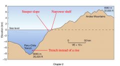
Looking at Fig 2.5 of page 39 , which (r/l) is tectonically active? Tectonically passive? Which one (active or passive) lacks a continental rise?
|
Active - left side - lacks a continetnal rise. Passive - right side
|
|
|
In which oean (Atlantic or Pacific) are there more Abyssal Planes?
|
There are more abyssal plains in the Atlantic because in the Pacfic the trenches traps the sediment as it comes off the shore.
|
|
|
In which ocean are there more trenches? Why
|
The sediment gets stuck in
the trenches and does not reach the open ocean basin floor and thus does not have the opportunity to create abyssal plains. |
|
|
Which spheres are involved in infiltration
|
•Biosphere
• Hydropshere |
|
|
Part of Earth made up of living organisms
|
Biosphere
|
|
|
Abbreviation for the depth at which calcium caronate dissolves
|
CCD
|
|
|
The Aleutian islands are this type of convergent plate boundary
|
Ocean-Continent Convergent Boundary
|
|
|
Features of the Ocean Floor: Abyssal Plains
|
• Flat, Very Flat areas of sea floor
• Form seaward of continental rise • Result of Sediment settling out of water and burying any or all topography • Deep |
|
|
Evidence for Continental Drift
|
1. ContinentalFit
2. Fossils 3. LinearMountainRanges |
|
|
Sea-Floor Spreading
|
• Plates in the middle of the ocean move away from each other
• ProposedbyHarry Hess |
|
|
Mid Ocean Ridges
|
• Seafloor spreading occurs at mid ocean ridges.
|
|
|
Subduction
|
• LithosphericPlates descend into mantle
• Destroysoceanic crust |
|
|
Magnetic Anomalies
|
• Iron in rocks aligns with magnetic field of Earth
• The Earth’s magnetic field reverses polarity • Reversals are recorded on seafloor • The pattern on one side of an ocean is a mirror image of the pattern on other side |
|
|
What causes the plates to move?
|
Convection
|
|
|
Convection
|
• Convection is the mechanism for plate movement.
– Heat rises (seafloor spreading) – Cold sinks (subduction) |
|
|
Plate Boundary Movement
|
• Plate boundaries can be classified as 3 different types depending on the dominant direction of movement.
– Plates can move away from each other ← → – Plates can crash into each other → ← – Plates can slide past each other |
|
|
Divergent Plate Boundaries
|
• Platesmoveaway from each other (seafloor spreading occurs here)
• Forms mid-ocean ridges |
|
|
Divergent Plate Boundary
|
• NewOceancrustis formed
|
|
|
Features of Divergent Boundaries: Pillow Basalts
|
• Pillowshapedrocks formed from lava flows under water
|
|
|
Features of Divergent Boundaries: Hydrothermal Vents
|
• Underwater Hot Springs
• Rich in minerals and chemicals, • Supportlarge communities of organisms by chemosynthesis Examples MAR- Mid-Atlantic Ridge EPR- East Pacific Rise RS- Red Sea IR- Indian Rise |
|
|
Convergent Plate Boundaries Subtype A: Oceanic-Oceanic Convergent
|
• Oceaniccrustcollides with oceanic crust
• Oceaniccrustis destroyed • Thedenserplate subducts Examples A- Aleutian Islands J- Japan |
|
|
Oceanic-Oceanic Subduction Zone
|
• Denser plate subducts under less dense plate
• Deep sea trench forms where 2 plates meet • Subducting plate partially melts- creating a chain of volcanoes parallel to the trench called a volcanic island arc |
|
|
Volcanic Island Arc
|
Aleutian Islands
|
|
|
Convergent Plate Boundaries Subtype B: Oceanic-Continental Convergent
|
• OceanicPlatecollides with Continental Plate
• Oceaniccrustis destroyed • Thedenserplate subducts |
|
|
Oceanic-Continental Convergent
|
Examples
A- Andes Mountans C- Cascades |
|
|
Convergent Plate Boundaries Type 3: Continental-Continental Convergent
|
• Continental plate collides with a continental plate
• No Subduction • No Volcanoes • Collidingcrustpushes upward creating mountain ranges Examples A- Alps H- Himalayas |
|
|
Continental-Continental Convergent Plate Boundary
|
Himalayas
|
|
|
Oceanic-Oceanic
|
– Ocean on both sides- if you are surround by ocean, you must be on an island
|
|
|
Oceanic-Continental
|
– Ocean on one side- if you are between the ocean and the continent- you must be at the beach- look for a boundary on a coastline
|
|
|
Continental-Continental
|
– In the middle of the continent- no where near the ocean
|
|
|
Transform Plate Boundaries
|
• Plateslidepasteach other
• No volcanoes • Transformboundaries connect other plate boundaries. • Examples S- San Andreas Fault |
|
|
Transform Plate Boundaries connect other plate boundaries
|
• The San Andreas Fault (Transform) connects the Juan de Fuca Ridge (Divergent) to the East Pacific Rise (Divergent) in the Gulf of California
|
|
|
Hot Spots
|
• NOT A PLATE BOUNDARY!!!
• Mantle plume- stationary column of heat from mantle • Platemovesovertop of mantle plume • Spotoncrustover mantle plume is called a “Hot Spot” |
|
|
Pacific Plate
|
The Pacific Plate moves over the mantle plume. Whichever part of the plate is over the mantle plume has active volcanoes. The volcanoes that have moved away from the mantle plume are extinct.
|
|
|
Examples of a Hot Spot
|
Examples
H- Hawaii Y- Yellowstone |
|
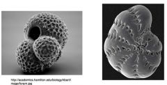
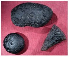
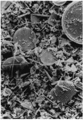
What is this a picture of?
|
Foraminifera
|
|
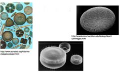
What is this a picture of?
|
Diatoms
|
|
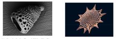
What is this a picture of?
|
Radiolarians
|
|
What is pictured here?
|
Manganese Nodules
|
|
What is this a picture of?
|
Ooliths
|
|
What is this a picture of?
|
Siliceous Sediments
|
|
What is this an image of?
|
Meteorites
|
|
What is this a picture of?
|
Space dust
|
|
What is this a picture of?
|
Tektites
|
|
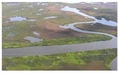
What is this a picture of?
|
Wetlands
|
|
What is this a picture of?
|
Calcareous Ooze
|
|
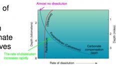
What is this diagram showing?
|
Carbonate Compensation Depth (CCD)
|
|

|
White Cliffs of Dover- formed from rock (rock type is chalk) made of calcareous ooze
|
|
|
Siliceous Ooze
|
|
|
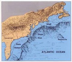
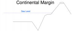
Passive Continental Margin- U.S. East Coast
|
|
|
Passive Continental Margin
|
• • •
Continental Shelf – Nearly flat Continental Slope – Anglebetween1°and25° Continental Rise – Not as steep as the continental slope – Marks the boundary between continental and oceanic crust |
|
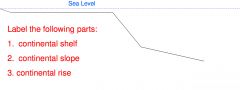
Label the following parts
|
|
|

Continental Margins- the boundary between oceanic and continental crust
|
2 types:
Figure 2.5, page 39 1. Passive Continental Margins- no plate boundary 2. Active Continental Margins- at/near a plate boundary |
|
|
Continental Crust
|
• Mostlygranite
• Thicker • Less Dense |
|
|
Continental Rise
|
– Not as steep as the continental slope
– Marks the boundary between continental and oceanic crust |
|
|
Continental Slope
|
Anglebetween1°and25°
|
|
|
Continental Shelf
|
Nearly Flat
|
|
What is this an example of?
|
An active continental margin
|
|
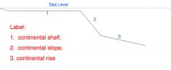
Simplified Diagram of an Active Continental Margin
Label the following parts: 1. continental shelf 2. continental slope 3. deep sea trench. |
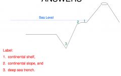
Label: 1. continental shelf, 2. continental slope, and 3. deep sea trench.
|
|
Q: Which one (right or left) is tectonically active? Tectonically passive?
Q: Which one (active or passive) lacks a continental rise? |
• Active- left side- lacks a continental rise
• Passive- right side |
|
|
Lithogeneous Sediment
|
• Sediment from rocks
• Result of weathering and erosion |
|
|
Classification of Lithogeneous Sediment
|
• Based on grain size
– Mud – very small (think of flour or powdered sugar) – Sand- less than 2 mm in size (think of granulated sugar or a sand box) – Gravel- anything bigger than 2 mm |
|
|
Sorting Lithogeneous Sediment
|
• Howmanyofthe grains are the same size.
– Well sorted- all grains same size – Poorly sorted- grains of all different sizes |
|
|
Lithogeneous SedimentComposition
|
• Mostlysilicates
• Quartzismost common because it is – 1. Extremely common – 2. Durable |
|
|
Source of Lithogeneous Sediment
|
• Streams and run-off from continents
• Wind – Blows dust and clay sized particles to ocean • Glaciers – Calving- when a piece of the glacier breaks off, forms icebergs • Landslides |
|
|
Biogeneous sediments
|
• From living organisms or their remains – Includes shells, bones, coral, skeletal parts – Includes excretions and secretions
|
|
|
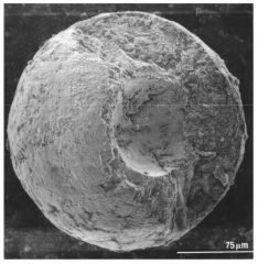
Calcareous Organisms
|
• Makeshellsoutof CaCO3 (calcium carbonate)
Examples • Foraminifera – Single cells • Coccolithophore – single-celled algae – photosynthetic |
|
|
Calcareous Sediments
|
• Dissolve in deep water • Found at depths less than ~4500 m
|
|
|
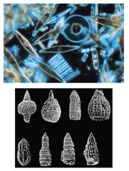
Siliceous Sediments
|
• Makeshellsoutof
SiO2 (silica) Examples • Diatoms – Single celled algae – Photosynthetic • Radiolarians – Single celled |
|
|
Hydrogeneous Sediments
|
Precipitated from seawater
|
|
|
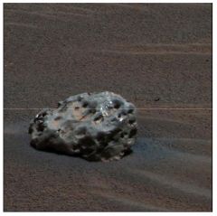
Manganese Nodules
|
• Blacknodules
• Contain Manganese, Iron, copper, cobalt, and nickel • Formascoatingson other particles |
|
|
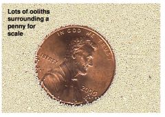
Ooliths
|
• Tinyspheresof calcite
• Precipitateoutof seawater |
|
|
Cosmogeneous Sediment
|
• Come from space – Meteorites – Space Dust – Tektites
|
|
|
The type of plate boundary where two plates collide
|
Convergent Plate
|
|
|
The type of bond holding one water molecule to another water molecule
|
Hydrogen Bond
|
|
|
Frozen part of the Hydrosphere
|
Cryosphere
|
|
|
Marine Sediment from space
|
Cosmogeneous Sediment
|
|
|
Part of the earth made up of living organisms
|
Biiosphere
|
|
|
An example of continental-continental convergent plate boundary
|
Himalayas
|
|
|
The type of boundaries where plates move away from each other
|
Divergent plate boundaries
|
|
|
Liquid water changes to water vapor without boiling
|
Evaporation
|
|
|
Abbreviation for the depth at which calcium carbonate dissolves
|
CCD
|
|
|
The mechanism for plate movement
|
Convection
|
|
|
Tye of boundary where two plates slid past each other
|
Transform plate boundaries
|
|
|
Solid form of methane found in sediment on continental shelf and slope
|
Methane Hydrate
|
|
|
Sediment that has its source from life
|
Biogeneous Sediment
|
|
|
One of the organisms that make up Calcareous Ooze
|
Foraminifera
|
|
|
Type of crust that is thin composed of basalt rich in iron and magnesium. and is very dense
|
Oceanic Crust
|
|
|
Name of super-continent proposed by Wegener
|
Pangaea
|
|
|
Ring shaped island surrounding a lagoon, formed on eroding volcano
|
Coral Atol
|
|
|
When pieces of the glacier breaks off, forms icebergs
|
Calving
|
|
|
Breakdown of rock material either physically or chemically
|
Weathering
|
|
|
Flat, very flat areas of sea floor
|
Abyssal Planes
|
|
|
Sediment coming from weather and erosion on the continents
|
Lithogeneous Sediment
|
|
|
Type of sat elite that remains over a fixed point on the earth
|
Geostationary
|
|
|
Sediment is precipitated from seawater
|
Hydrogenous Sediment
|
|
|
Near shore lithogeneous deposits
|
Neritic Deposits
|
|
|
Forms where a plate move over a mantle plume
|
Hot Spot
|
|
|
The most common composition of lithogeneous sediment
|
Quartz
|
|
|
Example of divergent plate boundary
|
• East Pacific Ridge
• Red Sea • Indian Rise • Mid Atlantic Ridge |
|
|
Formed from rain and snow
|
Precipitation
|
|
|
Type of crust that is thick, mostly composed of granite, rich in silicon and aluminum, and has low density
|
Continental Crust
|
|
|
Part of Earth that includes water in solid, liquid, ad gaseous forms
|
Hydrosphere
|
|
|
Ocean Sediments
|
• Various materials settle through the water column and accumulate on the ocean floor
• Layers represent a record of Earth history, including: – Movement of tectonic plates – Past changes in climate – Ancient ocean circulation patterns – Cataclysmic events |
|
|
Collection ocean sediments
|
• Specially designed ships collect cores by rotary drilling
• Cores allow scientists to analyze ocean sediment |
|
|
The 4 main types of sediment
|
• Lithogenous = composed of fragments of pre-existing rock material
• Biogenous = composed of hard remains of once-living organisms • Hydrogenous = formed when dissolved materials come out of solution (precipitate) • Cosmogenous = derived from outer space |
|
|
Origin of Lithogenous sediment
|
• Forms by:
– Weathering = breakup of exposed rock – Transportation = movement of sediment – Deposition = settling and accumulation |
|
|
Lithogenous sediment composition
|
• Most lithogenous sediment is composed of quartz, which is:
– Abundant – Chemically stable – Durable |
|
|
Lithogenous sediment texture
|
• Texture includes:
– Grain size – Sorting – Rounding – Maturity |
|
|
Distribution of Lithogenous sediment
|
• Lithogenous sediment occurs as:
– Neritic (nearshore) deposits • Beaches • Continental shelves • Turbidites • Glacial-rafted debris – Pelagic (deep ocean floor) deposits • Abyssal clay |
|
|
Origin of Biogenous sediment
|
• Organisms that produce hard parts die
• Material rains down on the ocean floor and accumulates as: – Macroscopic shells, bones, teeth – Microscopic tests (shells) • If comprised of at least 30% test material, called Biogenous ooze |
|
|
Biogenous sediment composition
|
• Microscopic biogenous tests are composed of 2 main chemical compounds:
• Silica (SiO2) including opal (SiO2 · nH2O) • Diatoms (algae) • Radiolarians (protozoan) • Calcium carbonate or calcite (CaCO3) • Coccolithophores (algae) • Foraminifers (protozoan) |
|
|
Examples of silica-secreting microscopic organisms
Siliceous ooze |
• Silica-secreting organisms accumulate to form siliceous ooze (>30% siliceous test material)
|
|
|
Examples of calcite-secreting microscopic organisms
Calcareous ooze |
• Calcite-secreting organisms accumulate to form calcareous ooze (>30% calcareous test material)
|
|
|
Biogenous ooze turns to rock
|
• When biogenous ooze hardens and lithifies, can form:
– Diatomaceous earth (if composed of diatom-rich ooze) – Chalk (if composed of coccolith-rich ooze) |
|
|
Distribution of biogenous ooze
|
• Most biogenous ooze found as pelagic deposits
• Factors affecting the distribution of biogenous ooze: – Productivity (amount of organisms in surface waters) – Destruction (dissolving at depth) – Dilution (mixing with lithogenous clays) |
|
|
Distribution of siliceous ooze
|
• Silica slowly but steadily dissolves in seawater
• Siliceous ooze found where it accumulates faster than it dissolves |
|
|
Distribution of calcareous ooze
|
• Calcite dissolves beneath the calcite compensation depth (CCD) at 4.5 km
• Calcareous ooze can be found below the CCD if it is buried and transported to deep water |
|
|
Origin of hydrogenous sediment
|
• Hydrogenous sediment forms when dissolved materials come out of solution (precipitate)
• Precipitation is caused by a change in conditions including: – Changes in temperature – Changes in pressure – Addition of chemically active fluids |
|
|
Types of hydrogenous sediment
|
• Manganese nodules
• Phosphates • Carbonates • Metal sulfides • Evaporite salts |
|
|
Cosmogenous sediment
|
• Cosmogenous sediment is composed of material derived from outer space
• Two main types: • Microscopic space dust • Macroscopic meteor debris • Forms an insignificant proportion of ocean sediment |
|
|
Mixtures
|
• Most ocean sediment is a mixture of sediment types
• One type of sediment usually dominates, allowing it to be classified as primarily: – Lithogenous – Biogenous – Hydrogenous – Cosmogenous |
|
|
Worldwide distribution of neritic and pelagic sediment
Ocean sediments as a resource |
• Ocean sediments contain many important resources, including:
– Petroleum – Gas hydrates – Sand and gravel – Evaporative salts – Phosphorite – Manganese nodules and crusts |
|
|
Four Types of Sediment
|
• There are four basic types of marine sediments, all of which are grouped and ordered by the origin of their particles, the grain sizes, and where they are deposited.
• These four kinds include lithogenous, biogenous, hydrogenous, and cosmogenous. All of these are different from one another in some way but all share in common the tendency to collect along the floor of the oceans as a testament to many natural processes such as weathering, erosion, and collision. |
|
|
• Sediments can be classified BY ORIGIN:
|
Lithogenous = generated from rocks Hydrogenous = generated from water Biogenous = generated from life
|
|
|
SEDIMENTS
|
• Sediments are typically laid down in layers, or strata, usually in a body of water.
• On the seafloor, sediments are thinnest near spreading centers (young seafloor) and thicker away from the ridge, where the seafloor is older and has more time to accumulate. Sediments are also much thickest near continents. |
|
|
Sediments can be classified BY AREA OF DEPOSIT:
|
Neritic = deposited on the continental shelf
Pelagic = deposited beyond the continental shelf |
|
|
Lithogenous = broken bits of rock (the term "terrigenous" is often used interchangably with "lithogenous")
|
- Sediment layers are thickest near the continents, the source of lithogenous material, and thinner farther out to sea. - If you determine that the seds are lithogenous, next check grain size: are they fine, medium or coarse?
Sediments are coarsest near the continental source: the farther from the source, the finer the sediments. - Land areas highest above sea level have the fastest erosion, and the sea floor near mountains will have the most rapid sediment accumulation. - Running water is the main delivery mechanism. Wet climates have fast erosion on land, and rapid sediment deposition in nearby oceans. Arid regions have slower sedimentation rates. |
|
|
Turbidites
|
are sediments deposited by underwater landslides (turbidity currents), caused by earthquakes or over-loading of the seds on continental shelf. The seds are sorted out as they flow, and settle in a regular pattern: the coarses particles settle first, then medium, then fine. Repeated sequences of this graded bedding indicates that an are has had many underwater landslides.
|
|
|
Volcanic ash
|
is produced by violent volcanic eruptions. Ash then settles out of the atmosmosphere, through the ocean, and contributes to the sediment column. Where would this type of violent eruption occur?
|
|
|
Red Clays and Brown Muds
|
are very fine-grained, thin sediments found on the abyssal plains, where there isn't much contributing to the sediment column. These are the finest lithogenous particles from the continents, carried a long distance out to sea before settling out.
|
|
|
Lithogenous
|
Lithogenous = broken bits of rock (the term "terrigenous" is often used interchangably with "lithogenous")
- Sediment layers are thickest near the continents, the source of lithogenous material, and thinner farther out to sea. - If you determine that the seds are lithogenous, next check grain size: are they fine, medium or coarse? Sediments are coarsest near the continental source: the farther from the source, the finer the sediments. - Land areas highest above sea level have the fastest erosion, and the sea floor near mountains will have the most rapid sediment accumulation. - Running water is the main delivery mechanism. Wet climates have fast erosion on land, and rapid sediment deposition in nearby oceans. Arid regions have slower sedimentation rates. • Turbidites are sediments deposited by underwater landslides (turbidity currents), caused by earthquakes or over-loading of the seds on continental shelf. The seds are sorted out as they flow, and settle in a regular pattern: the coarses particles settle first, then medium, then fine. Repeated sequences of this graded bedding indicates that an are has had many underwater landslides. • Volcanic ash is produced by violent volcanic eruptions. Ash then settles out of the atmosmosphere, through the ocean, and contributes to the sediment column. Where would this type of violent eruption occur? • Red Clays and Brown Muds are very fine-grained, thin sediments found on the abyssal plains, where there isn't much contributing to the sediment column. These are the finest lithogenous particles from the continents, carried a long distance out to sea before settling out. |
|
|
Hydrogenous
|
precipitate chemically out of seawater. Ions dissolved in seawater combine to form minerals, which precipitate out as solids • Polymetal Sulfides: abundance of metals and sulfur compounds
- ions dissolved from ocean crust by hot water, precipitate when contact cold water; found at present or past sites of hydrothermal vents • Manganese Nodules: marble-sized to fist-sized lumps, rich in manganese, copper, nickel and silica precipitated from seawater - form a kind of cobblestone pavement on parts of the abyssal plains; always at the top of the sediment column - form where sediment accumulation rate is very slow: far from continents and plate edges, far from biol. productive zones • Evaporites: layered deposits of salt - form in arid regions; form when a body of seawater becomes isolated, the water evaporates & leaves behind solid salt deposit • Phosphorite Nodules: small spherical masses rich in phorphorus Part 2 of HANDOUT 6 - form on continental shelf mostly, in areas where the concentration of phosphorus in the water exceeds 15% |
|
|
Biogenous
|
remains of organisms that die, settle to the sea floor
- The vast majority of biogenous particles in marine sediments come from microscopic floating organisms called plankton. - Biogenous seds will be thickest in areas where the water is rich in nutrients (plant food) so that there is abundant biological productivity. - Near coastlines, the biogenous component of sediments may be "diluted" or masked by the rapid input of lithogenous sediments. - If a sediment is > 30% biogenous, we call it an ooze. - If it is an ooze, check the compostion. Is it calcareous ooze or siliceous ooze? The type of ooze depends on two things. (1) the type of organisms that live in the surface water at that location (2) whether the material dissolves or is decayed as it settles through the water column • Calcareous ooze: made up mostly of calcium-carbonate (CaCO3) shells - main organisms: coccolithophores (plant plankton) & foraminifera (animal plankton) - note chalky appearance of the CaCO3 tests (shells) under the microscope - CaCO3 -bearing organisms flourish where the surface water is fairly warm CaCO3 dissolves quickly in cold water, so they are not so abundant where surface water is cold - Calcareous sediments are found mostly on shallow sea floor, because it dissolves as it settles through the cold water in the deep sea Dissolving of CaCO3 is also affected by water chemistry and pressure (depth) - The level below which we don't see carbonate sediments is called the CCD (Carbonate Compensation Depth). The depth of the CCD varies: Atlantic Ocean = 5000 m; South Pacific = 4500 m North Pacific = <4000 m • Siliceous ooze: made up mostly of silica (SiO2) shells - main organisms: diatoms (plant plankton) & radiolaria (animal plankton) - note the fine structure and glassy appearance of the silica tests (shells) under the microscope - these organisms flourish where the surface water is cold, rich & biologically productive. Siliceous oozes are formed under upwelling zones. - Siliceous ooze is found on deeper sea floor, below the level where carbonates have dissolved. - siliceous material also dissolves a bit in seawater, but much more slowly than carbonate material. • Organic muds = high concentration of organic tissue (the soft parts) -occur where biological productivity at the surface is great, & not all of the organic tissue decays before it is buried in sediment column. - usually black, sticky muds, devoid of oxygen (anoxic); often have that "rotten egg smell" produced by the decay of organics in the seds - marine environments that accumulate organic-rich muds set the stage for the production of an important resource -- hydrocarbons • Hydrocarbons (oil & gas) are formed when organic material (carbon, oxygen, hydrogen) is buried and chemically converted where - the sedimentation rate is fast enough to bury the organics before they decay away; terrigenous and neritic deposits. - this conversion is speeded up if the heat flow in the area is a little elevated, but not too hot - the fluid oil & gas migrates through sedimentary layers that are "permeable" (have pore spaces that let liquids pass through) - the geologic environments that have all the necessary requirements for the formation/accumulation of hydrocarbons include ß rifted margins that become passive continental margins: example North Slope of Alaska, Gulf of Mexico / Caribbean Sea ß old river deltas: example in deeper layers of the Mississippi River delta ß marginal sea, behind island arcs: example Bering Sea, Sea of Japan Part 2 of HANDOUT 6 Part 2 of HANDOUT 6 ß old ocean basins that are closing up: example Persian Gulf, which is the last remnant of the Tethys that has closed up over time and compressed its sedimentary layers; this area contains 60% of the world's known oil supply. |
|
|
Pelagic sediments
|
Pelagic sediments, also known as marine sediments, are those that accumulate in the abyssal plain of the deep ocean, far away from terrestrial sources that provide terrigenous sediments; the latter are primarily limited to the continental shelf, and at some point were probably deposited by rivers.[1] Pelagic sediments that are mixed with terrigenous sediments are known as hemipelagic.
There are three main types of pelagic sediments:[2] 1. Siliceous oozes 2. Calcareous oozes 3. Red clays |
|
|
Oceanic-oceanic convergence
|
As with oceanic-continental convergence, when two oceanic plates converge, one is usually subducted under the other, and in the process a trench is formed. The Marianas Trench (paralleling the Mariana Islands), for example, marks where the fast-moving Pacific Plate converges against the slower moving Philippine Plate. The Challenger Deep, at the southern end of the Marianas Trench, plunges deeper into the Earth's interior (nearly 11,000 m) than Mount Everest, the world's tallest mountain, rises above sea level (about 8,854 m).
Subduction processes in oceanic-oceanic plate convergence also result in the formation of volcanoes. Over millions of years, the erupted lava and volcanic debris pile up on the ocean floor until a submarine volcano rises above sea level to form an island volcano. Such volcanoes are typically strung out in chains called island arcs. As the name implies, volcanic island arcs, which closely parallel the trenches, are generally curved. The trenches are the key to understanding how island arcs such as the Marianas and the Aleutian Islands have formed and why they experience numerous strong earthquakes. Magmas that form island arcs are produced by the partial melting of the descending plate and/or the overlying oceanic lithosphere. The descending plate also provides a source of stress as the two plates interact, leading to frequent moderate to strong earthquakes. |
|
|
Continental-continental convergence
|
The Himalayan mountain range dramatically demonstrates one of the most visible and spectacular consequences of plate tectonics. When two continents meet head-on, neither is subducted because the continental rocks are relatively light and, like two colliding icebergs, resist downward motion. Instead, the crust tends to buckle and be pushed upward or sideways. The collision of India into Asia 50 million years ago caused the Eurasian Plate to crumple up and override the Indian Plate. After the collision, the slow continuous convergence of the two plates over millions of years pushed up the Himalayas and the Tibetan Plateau to their present heights. Most of this growth occurred during the past 10 million years. The Himalayas, towering as high as 8,854 m above sea level, form the highest continental mountains in the world. Moreover, the neighboring Tibetan Plateau, at an average elevation of about 4,600 m, is higher than all the peaks in the Alps except for Mont Blanc and Monte Rosa, and is well above the summits of most mountains in the United States.
Above: The collision between the Indian and Eurasian plates has pushed up the Himalayas and the Tibetan Plateau. Below: Cartoon cross sections showing the meeting of these two plates before and after their collision. The reference points (small squares) show the amount of uplift of an imaginary point in the Earth's crust during this mountain-building process. |
|
|
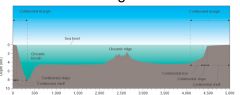
The earth's continents are constantly moving due to the motions of the tectonic plates. Closely examine the map below, which shows the 15 major tectonic plates.
|
As you can see, some of the plates contain continents and others are mostly under the ocean. The type of crust that underlies the continents is called continental crust, while the type found under the oceans is called oceanic crust. Continental crust is thicker — about 20 to 40 miles (35 to 70 km) thick — and usually older than oceanic crust, which is only 4 to 6 miles (7 to 10 km) thick. All the plates have names, usually referring to landmasses, oceans, or regions of the globe where they are located.
Tectonic Plates Map The border between two tectonic plates is called a boundary. All the tectonic plates are constantly moving — very slowly — around the planet, but in many different directions. Some are moving toward each other, some are moving apart, and some are sliding past each other. Because of these differences, tectonic plate boundaries are grouped into three main types. |
|
|
Transform boundaries
|
The zone between two plates sliding horizontally past one another is called a transform-fault boundary, or simply a transform boundary. The concept of transform faults originated with Canadian geophysicist J. Tuzo Wilson, who proposed that these large faults or fracture zones connect two spreading centers (divergent plate boundaries) or, less commonly, trenches (convergent plate boundaries). Most transform faults are found on the ocean floor. They commonly offset the active spreading ridges, producing zig-zag plate margins, and are generally defined by shallow earthquakes. However, a few occur on land, for example the San Andreas fault zone in California. This transform fault connects the East Pacific Rise, a divergent boundary to the south, with the South Gorda -- Juan de Fuca -- Explorer Ridge, another divergent boundary to the north.
The Blanco, Mendocino, Murray, and Molokai fracture zones are some of the many fracture zones (transform faults) that scar the ocean floor and offset ridges (see text). The San Andreas is one of the few transform faults exposed on land. The San Andreas fault zone, which is about 1,300 km long and in places tens of kilometers wide, slices through two thirds of the length of California. Along it, the Pacific Plate has been grinding horizontally past the North American Plate for 10 million years, at an average rate of about 5 cm/yr. Land on the west side of the fault zone (on the Pacific Plate) is moving in a northwesterly direction relative to the land on the east side of the fault zone (on the North American Plate). San Andreas fault gif Aerial view of the San Andreas fault slicing through the Carrizo Plain in the Temblor Range east of the city of San Luis Obispo. (Photograph by Robert E. Wallace, USGS.) Oceanic fracture zones are ocean-floor valleys that horizontally offset spreading ridges; some of these zones are hundreds to thousands of kilometers long and as much as 8 km deep. Examples of these large scars include the Clarion, Molokai, and Pioneer fracture zones in the Northeast Pacific off the coast of California and Mexico. These zones are presently inactive, but the offsets of the patterns of magnetic striping provide evidence of their previous transform-fault activity. |
|
|
OCEAN SEDIMENTS
|
TYPES (BY SOURCE):
Lithogenous ("rock-derived') Biogenous ("life-derived") Hydrogenous ("water-derived") Cosmogenous ("cosmic-derived") |
|
|
COSMOGENOUS SEDIMENTS
|
Micro-meteorites
silicates, metals, mixtures wide-spread, but not abundant Impacts of large extra-terrestrial bodies (asteroids, comets) Catastrophic results Cause of "mass extinctions"? -- dinosaurs |
|
|
YDROGENEOUS SEDIMENTS
|
(1) Direct precipitation (ppt) from sea water
(2) Sediment - sea water reaction "Salts" = Dissolved ions in sea water Evaporation of sea water in "restricted" basins Ppt. of "salts" -- NaCl (halite) and CaSO4.2H2O (gypsum) Manganese nodules Nodules and crusts of Mn & Fe oxides (Cu, Co, Ni) in deep ocean and along mid-ocean ridges. Origin (?) -- source of metals Sediments Sea water Hydrothermal activity (remember "black smokers") |
|
|
LITHOGENOUS SEDIMENTS
|
(1) Terrigenous sediments -- continental source
Continental rocks "Weathering" -- water - - chemical alteration -- freeze/thaw cycles -- wind abrasion Erosion and transportation -- streams and rivers -- wind -- glaciers Transport to continental margins (and possibly to Deep-sea floor) 75 % of all marine sediments are lithogenous Mostly stay ("trapped") on continental margins Pacific Ocean: terrigenous sediment trapped in margins and trenches; little transported to deep-sea floor. (2) "Red Clay" -- terrigenous and volcanic ash Transported to open ocean by winds and surface currents. Settles through water column -- pelagic clay. Common in deep oceans where other types are absent. |
|
|
BIOGENOUS SEDIMENTS -- produced directly by organisms
|
Warm, shallow seas -- shells of animals (clams, corals)
Open ocean (deep sea) -- "shells" of microscopic "plankton" Components of sediment-producing plankton: 1. CaCO3 (calcium carbonate) Coccolithophores Foramifera 2. SiO2.(+nH2O) (opaline silica) Diatoms Radiolarians Biogenic "oozes" -- > 30% of biogenous sediment Calcareous ooze Siliceous ooze |
|
|
Distribution of biogenous oozes:
|
1. Production in surface waters:
Biological productivity controlled by nutrients -- N and P "Upwelling" brings nutrients to surface waters Productivity high in upwelling zones 2. Dissolution in deep waters Deep waters "undersaturated" -- particles tend to dissolve "Carbonate Compensation Depth" (CCD) Calcareous oozes absent below CCD Atlantic: ~ 4,000 m Pacific: ~ 500 - 1,500 m Siliceous particles dissolve more slowly; depth is not an issue 3. Dilution by other sediments High input of terrigenous sediment "Dilutes" biogenous components to < 30 % |
|
|
SUMMARY -- Distribution of sediment on the sea floor (modern sediments)
|
Terrigenous: Continental margins and adjacent abyssal plains.
Manganese nodules: Deep basins, especially the Pacific. Red Clay: Deep ocean regions where there is very little biogenous or terrigenous sediment Calcareous oozes: Widespread in relatively shallow areas of the deep sea. Siliceous oozes: Polar and equatorial bands where nutrients are supplied to surface waters by vertical upwelling. |
|
|
Sources and origins of marine sediments
|
In the previous lecture, we discussed how sediments are classified according to where they are deposited (neritic, pelagic, etc.) and by their grain size (sand, silt, clay, etc.). Another useful and important classification scheme for classifiying ocean sediments is by their sources, or origins.
In terms of the total volume of ocean sediment, the two most important "types" of sediment in this classification are lithogenous ("rock-derived") and biogenous (produced by marine organisms). Other types are hydrogenous (produced by chemical reactions in sea water) and cosmogenous (particles from outer space). Let's consider those source/origin types in more detail. |
|
|
COSMOGENOUS SEDIMENTS
|
that accumulate in the oceans (and land) are essentially "micro-meteorites" whose composition can be either silicate (like the mantle), metal (like the core), or a mixture of the two.
- Although there is a continuous "rain" of these particles on Earth, cosmogenous sediments make up a very minor component of ocean sediments -- in fact, it takes an expert to identify them. - But throughout the history of our planet, very large extra-terrestrial bodies (large meteorites, asteroids, even comets) have collided with the Earth from time to time. - The results are catastrophic! -- a large, deep crater; molten rock and ash ejected into the atmosphere, world-wide fires. - Many scientists have concluded that major impacts cause "mass extinctions," like the extinction of the dinosaurs and 80% of all living species 65 m.y. ago. |
|
|
HYDROGENEOUS SEDIMENT
|
(1) direct precipitation from sea water, or
(2) as a new mineral from chemical reactions between sea water and sediments on the sea floor |
|
|
Manganese nodules
|
are oxides of the metals manganese (Mn) and iron (Fe). They also contain minor amounts of copper (Cu), cobalt, (Co), and nickel (Ni).
- Manganese nodules occur as nodules and crusts, primarily in deepest of oceans and near mid-ocean ridges. - Their origin is controversial. We do not know the source of the metals nor how and why they are concentrated in nodules. - The metals may be delivered as dissolved species or as sediments from land. - A more likely origin is volcanic activity and hydrothermal alteration of ocean crust at mid-ocean ridges. Remember the "black smokers?" Much of the suspended particles are Mn and Fe oxides. |
|
|
HYDROGENEOUS SEDIMENTS
|
(1) direct precipitation from sea water, or
(2) as a new mineral from chemical reactions between sea water and sediments on the sea floor "Salts" - - Sea water contains dissolved ions (about 3.5 % by weight). - When sea water undergoes extensive evaporation in bays or even large seas that are restricted from "communicating" (circulating) with the "open" ocean, the concentration of ions can increase to the point where they are "saturated" with respect to certain solids that we simply call "salts." - Important sea salts are NaCl (halite) and CaSO4.2H2O (gypsum). - Salts precipitate from "super-saturated" sea water in restricted basins and are deposited on the sea floor. "Manganese nodules" - - are oxides of the metals manganese (Mn) and iron (Fe). They also contain minor amounts of copper (Cu), cobalt, (Co), and nickel (Ni). - Manganese nodules occur as nodules and crusts, primarily in deepest of oceans and near mid-ocean ridges. - Their origin is controversial. We do not know the source of the metals nor how and why they are concentrated in nodules. - The metals may be delivered as dissolved species or as sediments from land. - A more likely origin is volcanic activity and hydrothermal alteration of ocean crust at mid-ocean ridges. Remember the "black smokers?" Much of the suspended particles are Mn and Fe oxides. |
|
|
Terrigenous sediments
|
are produced by the physical and chemical "weathering" (alteration) of rocks exposed on continents. Sedimentary particles are then eroded and transported from land to the oceans. Most sediment is carried by rivers, but winds and glaciers are also important transport agents. River-transported sediment is deposited on continental margins and mostly stays there. Only a small fraction is transported to the open ocean (e.g., by turbidity currents).
Terrigenous sediments make up 75 % of all the sediment that is deposited in the ocean. The thickest accumulations (up to 10 km!) occur in continental rises. But keep in mind that most terrigenous sediment remains on continental margins -- river deltas, bays, estuaries, as well as continental rises. In the Pacific, sediment from land is trapped in those environments and in marginal trenches. As a consequence, relatively little terrigenous sediment is transported to the deep-sea floor of the Pacific. |
|
|
LITHOGENOUS SEDIMENTS
|
in the ocean come in two varieties: (1) terrigenous ("land-derived") and (2) "red clay."
|
|
|
SUMMARY -- Distribution of sediment on the sea floor (modern sediments)
|
Terrigenous: - - continental margins and adjacent abyssal plains.
Manganese nodules: - - deep basins, especially the Pacific. Red Clay: - - deep ocean regions where not diluted by biogenic particles. Calcareous oozes: - - wide-spread in relatively shallow areas of the deep sea. Siliceous oozes: - - polar and equatorial bands where nutrients are supplied to surface waters by vertical upwelling. |
|
|
(Divergent)
|
- where two plates move away from each other resulting in new crust being formed.
|
|
|
(Convergent)
|
- where two plates move towards each other - in the case of a plate consisting of continental crust meeting a plate consisting of oceanic crust, the oceanic crust will be subducted and destroyed as it is less dense.
|
|
|
Convergent boundaries.
|
Plates may converge directly or at an angle. Three types of convergent boundaries are recognized:
• continent-continent • ocean-continent • ocean-ocean. |