![]()
![]()
![]()
Use LEFT and RIGHT arrow keys to navigate between flashcards;
Use UP and DOWN arrow keys to flip the card;
H to show hint;
A reads text to speech;
19 Cards in this Set
- Front
- Back
|
California's coastline is divided into two distinct sections north and south of ___. The north part has a NW direction while the south curves eastward creating more warmer currents and protection from winter storm waves. |
Point Conception |
|
|
With the exception of tsunamis, all ocean waves are generated by what? |
Winds blowing over the water surface. (They travel from storms far away without losing much energy). |
|
|
In the open ocean, the surface water moves in circular orbits to transmit the waves, leaving the ocean bottom unaffected. When waves reach the shallow water of the coastline, they feel the bottom. They slow down and the ___ of the wave slows down most while the __ wave overruns the base, and the wave breaks. The depth of breakage depends on the wave size. __ waves will break further from the shore. The zone of breaking waves along a coastline, the ___, is constantly subjected to wave attack. |
bottom; top; large; surf zone |
|
|
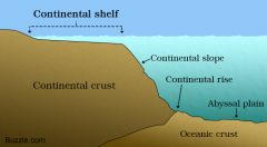
The continental shelf is relatively ___ along most of the coast north of Point Conception meaning the bottom drops off quickly from the beach into deep water. Even large waves arrive close to the shoreline before breaking. Wave energy along unprotected coastlines is high because the steep, ___ shelf. Wave energy is high on straight beaches that face ___ because they directly face incoming winter waves. The open beach at ____ unprotected by any nearby land masses, is one of CA's highest energy beaches. |
narrow; narrow; northwest; Point Reyes National Seashore |
|
|
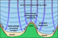
Rocky points that protrude into the ocean are attacked by waves more ___ than embayments in the shoreline. A wave front is slowed down as it approaches the rocky headlands, but continues into the embayment for a great distance before breaking. As a resuly, the wave fronts are bent, or ___. Eventually the headbands erode by waves and the protected embayments tend to fill in with beach sediment and eventually this ___ the coastline. |
Fiercely; refracted; straightens |
|
|
Mavericks in San Mateo County is world famous spot for enormous surfing waves. A zone of offshore rocks along a fault zone combines with seasonal waves to produce waves 25/30 feet. |
Top 3 surf beaches Black Beach San Diego, Trestles San Clemente, Malibu |
|
|
___ CA coast is particularly famous for its long, smooth stretches of sand. Most of CA's beaches are narrow strips of sand at the base of sea cliffs, but some are backed by coastal lowlands. Some beaches can be made from __ instead of sand (cuz near conglomerate cliff). This and sad are well rounded and sorted by the tumbling action of the ___. |
Southern; Gravel; waves |
|
|
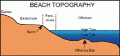
A __ is a narrow strip of sand parallel to the coastline. Above the water level is the __ where sand has been carried to shore by waves. Below the water, out to about 10 meters of water depth, are elongated piles of sand parallel to the beach, called ____. Both are part of the beach system, and the sand on a beach is in almost constant motion. During winter, storm waves move much of the sand to offshore bars (berm becomes narrow). Summer has small waves so no worry. |
beach; beach berm; offshore bars |
|
|
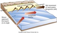
Most beach sand is supplied from __ that empty into the ocean. Eroding sea cliffs a lesser amount too. From the river mouths, sand is carried along the coast by ___ which result from the interaction between approaching waves and the coastline. The largest waves originate from winter storms in North Pacific and they approach coast from northwest and are refracted. Created by obliquely breaking waves. These currents transport sand along the beach and in the surf zone in right angles. Sand moving with the waves is also carried parallel to the shore. This type of sand movement is known as ___. |
rivers; longshore currents; longshore transport |
|
|
Because largest waves approach the California coast from ___, the overall direction of longshore transport is generally from __ to ___. North of Point Conception transports this way. The South of Point Conception is carried __ and then ___ because of the bend in the coastline. |
Northwest; north to south; east; southweast |
|
|
Most longshore transport is from north to south in CA, but complex patterns develop from variation in the coastline's orientation & seasonal variations in wave approach. Human activities can interrupt longshore transport, resulting in coastal erosion or beach starvation. Name the 5 ways sand transport is blocked. |
- Summer & autumn storms change direction - submarine canyons block transport and forces sand seaward into deep water. - Man made Structures act like a dam to halt flow of sand. Beaches down-current are cut off from sand supply & need to be artificially replenished. - Change in coastline like embayment may cause current to build a ridge of sand beyond the bend forming a spit that projects into the bay. -Sand Dunes |
|
|
Longshore transport can hit an embayment and build a ridge of sand beyond the bend forming a ___. This can grow until it completely seals off an embayment from the open ocean, but broken during winter months. |
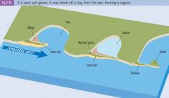
Spit |
|
|
Most of CA's coastline is being uplifted due to tectonics at a faster rate than the postglacial rise in sea level, resulting in ____ coastline. They are characterized by rocky shores, steep beaches, cliffs, wave-cut platforms, and marine terraces. Small pocket beaches and sea stacks here. |
emergent; sea stacks. |
|
|
Most of CA's coast is steep & rocky. Instead of long, straight sandy beaches, shoreline is composed of small ___ tucked between rocky points. |
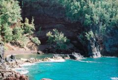
pocket beaches |
|
|
Along many rocky shores, wave erosion has isolated protruding points from the mainland, forming ___. |
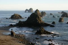
sea stacks |
|
|
___ are ancient marine shorelines, or strandlines. They consist of a relatively flat ____. eroded by waves in the surf zone, and a cover of beach sand. They are believed to be formed during times when worldwide sea levels are __. As tectonic uplift causes the coastline to rise from the sea, new platforms are cut at lower levels, and the former platforms are lifted above sea level to become terraces. |
Marine Terraces |
|
|
Marine terraces represent former sea level positions so they are great indicators of ___ rates. The 125,000 year old terrace in CA is found at 12.5 to 50 meters elevation. Terraces also record any tilting, folding, and faulting that have occurred since they formed. The shoreline angles can be thought of as geologic level lines. Wherever they are warped, tectonic activity must have deformed them. |
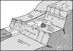
uplift |
|
|
___ or ___ coasts are present at the mouths of rivers or at localities where the coastline has been tectonically down-dropped. This results in tidal marshes, lagoons, or estuaries forming at the mouths of rivers. Estuaries at the mouth of drowned rivers are important habitats for aquatic species and birds (Salmon & Steelhead fish which need freshwater then move to ocean in adulthood). |
submerged coastlines or drowned coasts; Ex. San Francisco Bay. |
|
|
____ poses a continuing threat to developments along much of the CA coastline. Tremendous energy from waves is pounded against sediment. It eats away at the cliffs to replenish the system with sediment causing large rocks to fall from cliffs. It is episodic, with major cliff retreat, landsliding, and sand removal. The rate is determined by several factors: orientation of the coast, height of storm waves, and erodibility of the rocks along the shore. |
Coastal erosion; Ex. Redondo beach storm waves threw 5 cm rocks more than 30 meters in the air. Half Moon Bay had a breakwater to protect harbor but eventually erosion got them. |