Reading...
![]()
Play button
![]()
Play button
![]()
Use LEFT and RIGHT arrow keys to navigate between flashcards;
Use UP and DOWN arrow keys to flip the card;
H to show hint;
A reads text to speech;
149 Cards in this Set
- Front
- Back
|
UK METFORM
SEV |
Severe
|
|
|
UK METFORM
SFC |
Surface
|
|
|
UK METFORM
STNR |
Stationery
|
|
|
UK METFORM
TL |
Until
|
|
|
UK METFORM
VAL |
In valleys
|
|
|
UK METFORM
VSP |
Vertical speed
|
|
|
UK METFORM
W |
West or Westerly
|
|
|
UK METFORM
WDSPR |
Widespread
|
|
|
UK METFORM
BASE |
Cloud Base (in thousands of feet amsl)
|
|
|
UK METFORM
BECMG |
Becoming
|
|
|
UK METFORM
CIT |
Over large cities or towns
|
|
|
UK METFORM
COT |
At the coast
|
|
|
UK METFORM
E |
East or Easterly
|
|
|
UK METFORM
FM |
From
|
|
|
UK METFORM
FPM |
Feet per minute
|
|
|
UK METFORM
GEN |
Generally
|
|
|
UK METFORM
INTSF |
Intentisfying
|
|
|
UK METFORM
ISOL |
Isolated
|
|
|
UK METFORM
LAN |
Inland or over land
|
|
|
UK METFORM
LOC |
Locally
|
|
|
UK METFORM
MAX |
Maximum
|
|
|
UK METFORM
MOD |
Moderate
|
|
|
UK METFORM
MON |
Above or covering mountains
|
|
|
UK METFORM
MTW |
Mountain waves
|
|
|
UK METFORM
N |
North or Northerly
|
|
|
UK METFORM
OCNL |
Occasional
|
|
|
UK METFORM
S |
South or Southerly
|
|
|
UK METFORM
SEA |
At sea
|
|
|
METAR/TAF SURFACE WIND
G |
Wind gust
|
|
|
METAR/TAF SURFACE WIND
00000 |
Wind calm
|
|
|
METAR/TAF SURFACE WIND
VRB |
Variable wind direction
|
|
|
METAR/TAF SURFACE WIND
V |
Variation in wind direction of 180 degress or more, provided the wind speed is greater than 4 knots
|
|
|
METAR/TAF VISIBILITY
9999 |
Visibility greater than 10km
|
|
|
METAR/TAF VISIBILITY
0000 |
Visibility less than 50m
|
|
|
RVR
|
Runway visual range
|
|
|
METAR/TAF WEATHER
MI |
Shallow
|
|
|
METAR/TAF WEATHER
BC |
Patches
|
|
|
METAR/TAF WEATHER
DR |
Drifting
|
|
|
METAR/TAF WEATHER
BL |
Blowing
|
|
|
METAR/TAF WEATHER
SH |
Showers
|
|
|
METAR/TAF WEATHER
TS |
Thunderstorms
|
|
|
METAR/TAF WEATHER
VCTS |
Thunderstorms in the vicinity
|
|
|
METAR/TAF WEATHER
FZ |
Supercooled
|
|
|
METAR/TAF WEATHER
- |
Light
|
|
|
METAR/TAF WEATHER
+ |
Heavy
|
|
|
METAR/TAF WEATHER
DZ |
Drizzle
|
|
|
METAR/TAF WEATHER
RA |
Rain
|
|
|
METAR/TAF WEATHER
SN |
Snow
|
|
|
METAR/TAF WEATHER
SG |
Snow grains
|
|
|
METAR/TAF WEATHER
IC |
Diamond dust
|
|
|
METAR/TAF WEATHER
PE |
Ice pellets
|
|
|
METAR/TAF WEATHER
GR |
Hail
|
|
|
METAR/TAF WEATHER
GS |
Small hail
|
|
|
METAR/TAF WEATHER
BR |
Mist
|
|
|
METAR/TAF WEATHER
FG |
Fog
|
|
|
METAR/TAF WEATHER
PR FG |
Partial fog / Fog banks
|
|
|
METAR/TAF WEATHER
FU |
Smoke
|
|
|
METAR/TAF WEATHER
VA |
Volcanic ash
|
|
|
METAR/TAF WEATHER
DU |
Widespread Dust
|
|
|
METAR/TAF WEATHER
SA |
Sand
|
|
|
METAR/TAF WEATHER
HZ |
Haze
|
|
|
METAR/TAF WEATHER
PO |
Well developed dust/sand swirls
|
|
|
METAR/TAF WEATHER
SQ |
Squalls
|
|
|
METAR/TAF WEATHER
FU |
Funnel clouds/tornado/waterspout
|
|
|
METAR/TAF WEATHER
SS |
Sand storm
|
|
|
METAR/TAF WEATHER
DS |
Dust storm
|
|
|
METAR/TAF WEATHER
VC |
In the vicinity (8km) of the airfield
|
|
|
TAF (ONLY) WEATHER
NSW |
No significant weather
|
|
|
METAR/TAF CLOUD
FEW |
Few (1-2 oktas)
|
|
|
METAR/TAF CLOUD
SCT |
Scattered (3-4 oktas)
|
|
|
METAR/TAF CLOUD
BKN |
Broken (5-7 oktas)
|
|
|
METAR/TAF CLOUD
OVC |
Overcast (8 oktas)
|
|
|
METAR/TAF CLOUD
CB |
Cumulonimbus
|
|
|
METAR/TAF CLOUD
TCU |
Towering cumulus
|
|
|
METAR/TAF CLOUD
SKC |
Sky clear
|
|
|
METAR/TAF CLOUD
NSC |
No significant cloud
|
|
|
METAR/TAF CLOUD
VV/// |
Sky obscured, vertical visibility cannot be assesed
|
|
|
METAR/TAF CAVOK
CAVOK |
Visibility: 10km or more
Cloud: No cloud below 500ft and no CB or TCU at any height Weather: NSW |
|
|
METAR/TAF SUPPLEMENTARY
///// |
Information not avilable
|
|
|
METAR/TAF SUPPLEMENTARY
RE |
Recent weather
|
|
|
METAR/TAF SUPPLEMENTARY
WS |
Windshear
|
|
|
METAR/TAF SUPPLEMENTARY
DENEB |
Fog disperal in operation
|
|
|
METAR/TAF SUPPLEMENTARY
TREND |
Trend indicator, a forecast change during the 2 hours following observation period
|
|
|
METAR/TAF SUPPLEMENTARY
BECMG |
Becoming
|
|
|
METAR/TAF SUPPLEMENTARY
TEMPO |
Temporary
|
|
|
METAR/TAF SUPPLEMENTARY
NOSIG |
No significant change during the forecast period
|
|
|
METAR/TAF SUPPLEMENTARY
PROB30 |
Probability 30%
|
|
|
TAF SUPPLEMENTARY
AMD |
Ammendment, when the original TAF is withdrawn and a new one issued
|
|
|
SIGMET
OBSC TS |
Thunder storms, Obscured by smoke haze or darkness
|
|
|
SIGMET
EMBD TS |
Embedded Thunder storms
|
|
|
SIGMET
FRQ TS |
Frequent Thunder Storms/Line Squall
|
|
|
SIGMET
LSQ TS |
A line squall of thunderstorms
|
|
|
SIGMET
HVYGR |
Heavy hail
|
|
|
SIGMET
TC |
Tropical Cyclone
|
|
|
SIGMET
SEV TURB |
Servere Turbulence
|
|
|
SIGMET
SEV |
Severe icing
|
|
|
SIGMET
FZRA |
Freezing Rain
|
|
|
SIGMET
SEV MTW |
Severe Mountain Waves
|
|
|
SIGMET
HVY DS |
Heavy/Widespread Dust storm
|
|
|
SIGMET
HVY SS |
Heavy/Widespread Sand Storm
|
|
|
SIGMET
VA |
Volcanic Ash
|
|
|
SIGMET
OBS |
Observed
|
|
|
SIGMET
FCST |
Forecast
|
|
|
SIGMET
MOV |
Movement in the hazard usually with speed and direction
|
|
|
SIGMET
STNR |
Stationery
|
|
|
SIGMET
INTSF |
Intensifying
|
|
|
SIGMET
WKN |
Weakening
|
|
|
SIGMET
NC |
No change
|
|
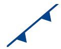
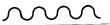
What does this symbol represent?
|
A cold front
|
|
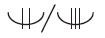
What do these symbols indicate?
|
Moderate and Severe icing
|
|

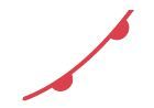
What do these symbols represent?
|
Moderate and Severe Turbulence
|
|

What does this symbol represent?
|
An occluded front
|
|
What does this symbol indicate?
|
The speed and direction of movement of a front.
|
|

What does this symbol represent?
|
A trough
|
|
What does this symbol represent?
|
A warm front
|
|
What does this symbol represent?
|
The boundary of an area of significant weather.
|
|

What does this symbol represent?
|
The centre of an area of high pressure
|
|

What does this symbol represent?
|
Clear Air Turbulence
|
|

What does this symbol represent?
|
Drizzle
|
|
What does this symbol represent?
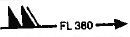
|
The flight level, speed and direction of the jetstream
|
|

What does this symbol represent?
|
Freezing Fog
|
|
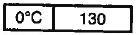
What does this symbol represent?
|
The freezing level in thousands of feet
|
|

What does this symbol represent?
|
Freezing precipiation
|
|

What does this symbol represent?
|
Freezing Ran
|
|

What does this symbol represent?
|
Hail
|
|

What does this symbol represent?
|
The intertropical convergence zone (ITCZ)
|
|

What does this symbol represent?
|
Light icing
|
|

What does this symbol represent?
|
Marked mountain waves
|
|

What does this symbol represent?
|
Moderate icing
|
|

What does this symbol represent?
|
Moderate Turbulence
|
|

What does this symbol represent?
|
The most recent movement of a weather feature
|
|

What does this symbol represent?
|
Severe dust or sand storm
|
|

What does this symbol represent?
|
Severe icing
|
|

What does this symbol represent?
|
Severe Line Squall
|
|

What does this symbol represent?
|
Severe turbulence
|
|

What does this symbol represent?
|
Shower
|
|

What does this symbol represent?
|
Snow
|
|
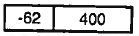
What does this symbol represent?
|
The temperature and level of the tropopause.
|
|

What does this symbol represent?
|
Thunderstorm
|
|

What does this symbol represent?
|
Tropical cyclone
|
|

What does this symbol represent?
|
The tropopause high centre and altitude
|
|

What does this symbol represent?
|
Widespread Fog
|
|

What does this symbol represent?
|
Widespread Mist
|
|

What does this symbol represent?
|
Widespread Smoke
|
|

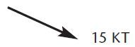
What does this symbol represent?
|
A wind arrow showing 10kts of wind
|
|

What does this symbol represent?
|
A wind arrow showing 50kts of wind
|
|

What does this symbol represent?
|
A widespread dust or sandstorm
|
|

What does this symbol represent?
|
Widespread Haze
|
|
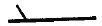
What does this symbol represent?
|
A wind arrow showing 5kts of wind
|