![]()
![]()
![]()
Use LEFT and RIGHT arrow keys to navigate between flashcards;
Use UP and DOWN arrow keys to flip the card;
H to show hint;
A reads text to speech;
41 Cards in this Set
- Front
- Back
|
GIS is a system designed to... |
efficiently capture, store, manipulate, analyze, and display geographically referenced information |
|
|
what 5 things does GIS include? |
|
|
|
what are the 2 major classes of spatial data? |
vector and rastor |
|
|
in the vector model, spatial entities are represented as... |
3 types of features:
|
|
|
vector data |
an example of an object in a data model (e.g. objects such as houses, roads, ponds, etc.) |
|
|
raster data |
an example of a field data model (e.g. elevation, rainfall, vegetation) |
|
|
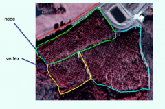
points are represented by... |
an X-value and a Y-value |
|
|
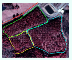
lines are represented by... |
a series of connected "X-Y" values (nodes and vertices) |
|
|
the lines connecting the X-Y values in line features are called _______ |
arcs |
|
|
polygons are represented by... |
areas bounded by lines |
|
|
what are the 2 types of vector data models? |
|
|
|
spaghetti data model |
|
|
|
topological model |
|
|
|
attributes data is stored in _________ |
tables |
|
|
table columns are called __________ |
fields |
|
|
table rows are called ___________ |
records |
|
|
table records are linked to __________ |
features (each record is associated with one and only one feature) |
|
|
what are the 3 attribute data types? |
|
|
|
text |
descriptive information/categorical |
|
|
integer |
ordered data, counts, etc. |
|
|
floating point |
continuous |
|
|
what are the 2 types of raster data? |
|
|
|
what is discrete raster data? |
unique categories (qualitative)
|
|
|
what is continuous raster data? |
large—or possibly infinite—number of values (quantitative) |
|
|
[ raster data ] space is modeled as... |
a grid of equal-sized cells
|
|
|
[ raster data ] each cell is known by... |
its row and column location |
|
|
[ raster data ] where is the origin usually? |
upper left corner |
|
|
[ raster data ] each cell has __________ value(s) and the values are coded to ______________ |
each cell has one and only one value and the values are coded to land cover, road types, etc. |
|
|
[ vector-raster conversion ] while vector point is represented by __________, raster point is represented by _____________ |
while vector point is represented by an X-Y value, raster point is represented by a grid cell that has a predefined set of dimensions |
|
|
[ vector-raster conversion ] while vector line is represented by __________, raster line is represented by _____________ |
while vector line is represented by a series of connected points, raster line is represented by grid cells that contain the line feature |
|
|
[ vector-raster conversion ] while vector polygon is represented by __________, raster polygon is represented by _____________ |
while vector polygon is represented by connected arcs that begin and end at the same node, raster polygon is represented by grid cells in which the polygon feature is a majority |
|
|
what is 1 problem with data conversion? |
some features (ponds, small canopy openings, rare vegetation types) can be lost entirely if they are smaller than the cell size |
|
|
[ changing cell size ] decreasing cell size enhances _____________, but ____________ also increase rapidly |
decreasing cell size enhances spatial resolution, but data storage requirements and time required for processing and display also increase rapidly |
|
|
the raster data model with continuous data |
|
|
|
attributes of raster data |
|
|
|
list 3 advantages of raster data |
|
|
|
list 3 disadvantages of raster data |
|
|
|
list 3 advantages of vector data |
|
|
|
list 3 disadvantages of vector data |
|
|
|
when should you use raster data? |
|
|
|
when should you use vector data? |
|