![]()
![]()
![]()
Use LEFT and RIGHT arrow keys to navigate between flashcards;
Use UP and DOWN arrow keys to flip the card;
H to show hint;
A reads text to speech;
56 Cards in this Set
- Front
- Back
|
What direction do lines of latitude run? |
East to west |
|
|
What do lines of latitude measure? |
Degrees north and south |
|
|
What direction do lines of longitude run? |
North to south |
|
|
What do lines of longitude measure? |
Degrees east to west |
|
|
What line of latitude is found at zero degrees? |
The Equator |
|
|
What line of longitude is found at zero degrees? |
Prime Meridian |
|
|
What are lines of latitude called? |
Parallels |
|
|
What are lines of longitude called? |
Meridians |
|
|
What is a large, natural stream of water that empties into an ocean, lake, etc? |
River |
|
|
What is a large, inland body of water? |
Lake |
|
|
What is a smaller stream that flows into a river, ocean, lake, etc? |
Tributary |
|
|
What is a natural elevation of the earth's surface having considerable mass and height greater than a hill? |
Mountain |
|
|
What is a body of water that is partially enclosed by land and is typically smaller than a gulf? |
Bay |
|
|
What is a large area of sea or ocean partially enclosed by land? |
Gulf |
|
|
What is a large, relatively flat, but elevated area of land? |
Plateau |
|
|
What is a large, relatively flat area of land? |
Plain |
|
|
What is a well-defined natural elevation of the earth's surface that is smaller than a mountain? |
Hill |
|
|
What is a piece of land that projects into a body of water and is connected with the mainland? |
Peninsula |
|
|
What is a land mass that is smaller than a continent and is surrounded by water? |
Island |
|
|
What body of water was used as an early exploration route for French and Spanish explorers? |
Gulf of Mexico |
|
|
What was an early highway for explorers, settlers, and immigrants? |
Atlantic Ocean |
|
|
What river was known as the "gateway to the west"? |
Ohio River |
|
|
What two rivers were used as transportation arteries for farm and industrial products? |
Mississippi and Missouri |
|
|
What river was explored by the Spanish explorer Coronado? |
Colorado River |
|
|
What river was explored by Lewis and Clark? |
Columbia River |
|
|
Inland port cities grew in the Midwest around what bodies of water? |
The Great Lakes |
|
|
What river forms the border between Texas and Mexico? |
Rio Grande |
|
|
What body of water was the early exploration destination? |
Pacific Ocean |
|
|
What body of water forms part of the Northeastern border with Canada and connects the Great Lakes to the Atlantic Ocean? |
St. Lawrence River |
|
|
fertile |
rich and capable of producing a lot |
|
|
erosion |
when wind or water eats away at the rock and soil |
|
|
continent |
one of the large landmasses of the earth |
|
|
gulf |
part of the ocean that is partially surrounded by land and is larger than a bay |
|
|
latitude |
lines that run east to west around the world (also called parallels) |
|
|
longitude |
lines that run north to south around the world (also called meridians) |
|
|
harbor |
a body of water along the shore deep enough for docking boats |
|
|
glacier |
a mass of ice moving very slowly |
|
|
Which geographic region has broad lowlands providing many excellent harbors? |
Coastal Plain |
|
|
Which geographic region contains the oldest mountain range in North America? |
Appalachian Highlands |
|
|
Which geographic region has rolling flatlands with many rivers, broad river valleys, and grassy hills? |
Interior Lowlands |
|
|
Which geographic region has hills worn by erosion and hundreds of lakes carved by glaciers? |
Canadian Shield |
|
|
Which geographic region has flat land that gradually increases in elevation westward? |
Great Plains |
|
|
Which geographic region is mostly grasslands? |
Great Plains |
|
|
Which geographic region contains the Continental Divide? |
Rocky Mountains |
|
|
Which geographic region has Death Valley? |
Basin and Range |
|
|
What is the Continental Divide? |
It determines the directional flow of rivers. |
|
|
What is Death Valley? |
The lowest point in North America |
|
|
Which geographic region contains fertile valleys and is located on the Pacific Coast? |
Coastal Range |
|

What is letter A? |
Coastal Plain |
|
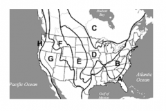
What is letter B? |
Appalachian Highlands |
|

What is letter C? |
Canadian Shield |
|

What is letter D? |
Interior Lowlands |
|

What is letter E? |
Great Plains |
|

What is letter F? |
Rocky Mountains |
|

What is letter G? |
Basin and Range |
|

What is letter H? |
Coastal Range |