![]()
![]()
![]()
Use LEFT and RIGHT arrow keys to navigate between flashcards;
Use UP and DOWN arrow keys to flip the card;
H to show hint;
A reads text to speech;
170 Cards in this Set
- Front
- Back
|
one acre = ? sq ft |
43,560 sq ft |
|
|
affirmative covenant |
commits a buyer to performing duties in the future |
|
|
restrictive covenant |
limitations and stipulations used in residential settings (aesthetics, pet control, storage) |
|
|
deed restrictions |
place limitations on the use of the property, typically by original developers, who determined what land would bee used for and can't be changed by future owners |
|
|
eminent domain |
power of the state to take private property without owner's censer, but with fair market value of the land compensation. |
|
|
business improvement districts |
used to fund public space improvements with the intention that it will enhance an area's appeal |
|
|
assessment |
valuation of property for the purpose of taxes |
|
|
easements |
legal right of government or another land owner to use one's property for a specific purpose |
|
|
building line |
utilized by communities principally to achieve planned street patterns |
|
|
setbacks |
required open space measured between property line and face of building |
|
|
ordinance |
a municipal law |
|
|
spot zoning |
a change in the zoning ordinance for a particular area |
|
|
Check |
Area 24 miles on a side defined by parallels/meridians; Divided into 16 townships |
|
|
Township |
Area 6 miles on a side; Divided into 36 - 1 mile sections |
|
|
Section |
1 mile square parcel of land containing 640 acres |
|
|
Quarter Section |
Area 1/2 miles on each side |
|
|
SPACE / SITE PLANNING HIERARCHY |
Total Building Group Component Building Activity Center Space Unit EX: Medical Campus > Acute Care Hospital > Surgery Department > Pre-Op Suite |
|
|
Planning Diagrams |
Matrix Chart Bubble Diagram Block Diagram |
|
|
Cardo & Decaumanus |
two major streets in a Roman town |
|
|
Loop Road |
a collector/distributor road into a shopping chenter |
|
|
Static Form |
parts are equal in size and located around a reference axis |
|
|
Dynamic Form |
parts are unequal in size and arrange around a reference axis |
|
|
Roads |
Local Collector Arterial Expressways |
|
|
Site Slope Percentage |
Vertical ________ X100 Horizontal |
|
|
Flat area slope (good for all activities) |
<4% |
|
|
Moderate slope |
4 - 10% |
|
|
Steep - unusable |
10 - 50% |
|
|
Very steep, subject to erosion |
+50% |
|
|
Construction Slope Percentage |
Vertical ________ X100 Horizontal |
|
|
Storm drains slope |
0.3% minimum |
|
|
Sanitary sewers |
0.4 - 1.4% |
|
|
Street surface drainage |
0.5% minimum |
|
|
Planted or large pavers |
1% minimum |
|
|
lawns |
25% max |
|
|
Planted banks |
50% max |
|
|
Parking area/lot |
5% max |
|
|
automobile ramps |
8% max |
|
|
sidewalks |
10% max |
|
|
streets/paved driveways |
10% max |
|
|
Angle of repose |
the greatest angle at which soil will lay without sliding |
|
|
Loose wet clay or silt angle |
30% |
|
|
Compact dry clay angle |
100% |
|
|
Wet sand angle |
80% |
|
|
Dry sand angle |
65% |
|
|
Gross Area =? + ? |
Net Area (commonly used area) + Circulation (structure/MEP/services) |
|
|
Floor Area Ratio (FAR) = ? / ? |
Gross Area ___________ Site Area |
|
|
Avoid intersections where the angle of roads is less than __% |
80% |
|
|
Cartridge Road |
loop distributor-collector drive with access to the local road |
|
|
At intersections with more than ___ cars per hour, a traffic light is required |
750 |
|
|
At intersections with more than ___ cars per hour, grade separations required |
3,000 |
|
|
Cloverleaf |
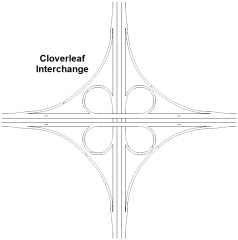
two level interchange |
|
|
direct left turn |
where two expressways intersect |
|
|
diamond |
expressways intersect secondary roads |
|
|
Maximum length of a block |
1,600 ft |
|
|
Cul-de-sacs |
400' max with 80' turn around |
|
|
2 lane highway with 9'-0" shoulders |
40' to 42' |
|
|
Typ. surface street width |
11' to 12' |
|
|
Min. curb radii at minor streets |
12' |
|
|
Min. curb radii at major streets |
50' |
|
|
Landscape strips width |
7' with trees 4' with grass or dirt |
|
|
Small cars turning radius |
16 - 19 feet |
|
|
Standard cars turning radius |
19 - 23 feet |
|
|
Large cars turning radius |
23 - 25 feet |
|
|
Busses / trucks turning radius |
43 - 50' |
|
|
Allow __ sf per car for parking and circulation |
400 sf/car |
|
|
Plan for ___ sf of parking for every 1,000 sf of shopping space |
3,000 - 4,000 |
|
|
Mothballing |
Term used in historic preservation when you designate certain areas to be repaired or restored at a later date, under a later contract |
|
|
4 Historical Preservation Treatments |
Preservation Rehabilitation Restoration Reconstruction |
|
|
Catchment Areas (Market, Trade, or Tributary Area) |
Geographic area from which the participants in an activity are drawn |
|
|
Residential Catchment Areas |
Determined by local transit systems |
|
|
Proctor Compaction Test |
Geotechnical tests to determine the maximum, practically achievable density of soils and aggregates |
|
|
Percolation Test |
Test method to determine the rate at which soil absorbs effluent. Used to test suitability of soil for a leach field. |
|
|
Baseline |
Parallel used as the basis for the east-west layout of the US Survey System |
|
|
Standard Parallels |
Parallels between the baselines in the US Survey |
|
|
Principal Meridian |
Meridian that serves as the basis for the north-south grid layout of the US Survey |
|
|
Guide Meridians |
Meridians between the principal meridians |
|
|
Benchmark |
Standard or point of reference against which things may be compared |
|
|
Metes and Bounds |
Verbal description of land that begins at a known point and describes the bearing and length of each side of the property until the point of the beginning is reached |
|
|
Contour Interval |
Change in elevation between two contours. Smaller scaled maps typically have a larger interval for clarity. |
|
|
Crown / Ridge |
Counters point "down" toward the lower elevation |
|
|
Swale / Valley |
Counters point "up" towards the higher elevation |
|
|
Hills |
Concentric circles with elevations getting higher towards the center |
|
|
Depression |
Concentric circles with the elections getting lower towards the center |
|
|
Frost Line |
Max depth at which soil will freeze |
|
|
Swamp |
Wetland that features permanent inundation of large areas of land by shallow bodies of water, generally with a substantial number of hummocks, or dry-land protrusions |
|
|
Swale |
An elongated depression in the land surface that is at least seasonally wet, is usually vegetated and is normally without flowing water |
|
|
Detention Pond |
Low lying area that is designed to temporarily hold a set amount of water while slowly draining to another location. They are more or less around for flood control when large amounts of rain could cause flash flooding if not death with properly. |
|
|
Retention Pond |
Designed to hold a specific amount of water indefinitely. Usually the pond is designed to have drainage leading to another location when the water level gets about the pond capacity, but still maintains a certain capacity. |
|
|
Riparian Rights |
System of rights and duties that determine the reasonable use, duties, and allocations of water to owners of waterfront property (includes bottomland, beach, and upland, but not the water itself). Owners can use water adjacent to their property, but can't infringe upon the rights of others to use the water. |
|
|
Sheet Flow |
Water that flows across paved surfaces |
|
|
Aquifer |
Permeable stratum of soil material that allows the passage of water under ground and is the water source for wells |
|
|
Hydrology |
The study of the occurrence, movement, and quality of water on a site |
|
|
Flume |
Elevated artificial channel that carries fast moving water and is used to transport things like logs and fish |
|
|
Weir |
Embankment, levee or dam formed to hold a river or steam or divert water flow |
|
|
Albedo |
How much radiant energy that is reflected by a surface 0 = Flat black, absorbs all heat 1 = Mirror Rate listed as a fraction |
|
|
Conductivity |
The speed with which heat passes through a material. Metals = high Soils/sand = low |
|
|
Macroclimate |
Based on latitude, elevation, and proximity to water. Water reduces temperature extremes. |
|
|
Microclimate |
Based on solar radiation, the angle between the ground and altitude |
|
|
Winter Solstice |
Least hours of sun Low sun angles |
|
|
Summer Solstice |
Most hours of sun High sun angle |
|
|
Vernal / Autumnal Equinox |
Equal hours of sun and dark |
|
|
Vortex |
When moving air encounters a building perpendicular to a broad face it flows both over roof and down the facade. Air collects at the base of the building which results in a high velocity swirl of wind. |
|
|
Air Pollution Temperature Inversion Phenomenon |
The air temperature at ground level is lower than high elevations causing the heavy, cold trapped air below to release pollutants |
|
|
Climate |
The composite of weather conditions including temperature humidity atmospheric pressure wind rainfall as well as site conditions including microclimate topography ground cover water elevation |
|
|
Ecology |
The science of the pattern of relationships between a group of organisms and their environment |
|
|
Ecosystem |
An environment of living organisms and non-living components |
|
|
3 Types of Building Surveys |
PRELIMINARY: basic CONSTRUCTION: precise, benchmarks POSSESSION: completed development |
|
|
2 Forms of Possession Site Survey |
GEODETIC: Precise, follows spherical shape of Earth PLANE: Assumes flate plane of Earth |
|
|
3 Types of Building Surveys |
Field Measurements: taken by hand Laser Scanning: quick Photogrammetry: establish control points and hand survey to get base coordinate system |
|
|
Eight basic categories of use |
Agricultural Commercial Government Industrial Institutional Natural Resources Open/Conservation Residential |
|
|
Methods to determine Land Value |
Comparison Method Development Method Residual / Income Approach Method Allocation Method |
|
|
Soil Types |
Gravel Sand Silt Clay |
|
|
Gravel |
Well drained Able to bear loads +2 mm |
|
|
Sand |
Well drained Can serve as foundation when graded 0.5 - 2 mm |
|
|
Silt |
Stable when dry Swells when frozen Do not use when wet .002 - .05 mm |
|
|
Clay |
Must be removed Too stiff when dry Too plastic when wet < .002 |
|
|
Levels of Soil |
A Level: Topsoil B Level: Minerals C Level: Partially weathered / fractured rock D Level: Bedrock |
|
|
Alluvium |
Soil, sand or mud deposited by flowing water |
|
|
Humus |
Soft dark soil containing decomposed organic matter Poor bearing capacity |
|
|
Loam |
Rich soil containing equal parts of sand, silt and clay |
|
|
Bearing Capacity |
Maximum pressure a foundation soil can take with harmful settlement |
|
|
Bearing capacity of bedrock |
10,000 psf |
|
|
Bearing capacity of well graded gravel/sand |
3,000 - 12,000 psf |
|
|
Bearing capacity of compacted sand/fill |
2,000 - 3,000 psf |
|
|
Bearing capacity of silt / clay |
1,000 - 4,000 psf |
|
|
Open warehouse boring location |
one in each corner and one in the middle |
|
|
Large structures boring location |
50' spacing |
|
|
Uniform conditions boring location |
100' - 500' spacing |
|
|
Types of boring |
Wash boring Augur boring Core boring Test Pit |
|
|
Spread Footing Foundation |
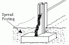
Most economical ($) delivers load directly to soil Area of the footing = load/safe bearing capacity |
|
|
Mat Foundation |
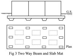
Expensive ($$$) Typ. only used when strata is weak Acts as one continuous foundation |
|
|
Belled Caissons |

Holes drilled to firm strata & concrete poured Really deep spread footings |
|
|
Socketed Caissons |
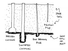
Hole drilled deep into strata Bearing capacity comes from end baring and frictional forces |
|
|
End Bearing Piles |

2-3x cost of spread footings Driven until tip meets firm resistance from strata |
|
|
Friction Pile |

Driven into softer soil Friction transmits the load between pile & soil |
|
|
Density |
Number of people per unit area |
|
|
Proxemics |
Study of spatial requirements of humans and the effects of population density on behavior, communication and social interaction |
|
|
Territoriality |
Behavioral system where person / group lays claim / defends an area |
|
|
Sociofugal |
Grouping of people arranged so that each can have privacy from others |
|
|
Typ. Human Comfort Zone in WINTER |
63 - 71 degrees |
|
|
Typ. Human Comfort Zone in SUMMER |
66 - 75 degrees |
|
|
Typ. Human Comfort Zone in TOLERABLE HUMIDITY |
30% - 60% |
|
|
Typ. Human Comfort Zone in UNCOMFORTABLE HUMIDITY |
+75% |
|
|
Area of a person |
3 sf |
|
|
Min width of sidewalks |
5' - 0" |
|
|
Min width of collector walks |
6' - 0" to 10' - 0" |
|
|
Smallest difference in 2 sounds the human ear can detect is ____ decibel(s) |
1 decibel |
|
|
Ahwahnee Principles |
a collection vision of how urban and suburban planning should follow certain fundamental principles regarding community size, integration, transportation, open space, pedestrian paths, native vegetation, water and energy use |
|
|
Asbestos Containing Materials (ACM) regulated by |
EPA OSHA State Agencies Local Agencies |
|
|
Permissible Exposure Limit (PEL) |
Standard that sets the number of asbestos fibers a worker can be exposed to |
|
|
National Emission Standards for Hazardous Air Pollutants (NESHAP) |
EPA regulation that dictates requirement of ACM removal before remodel/demo in order to prevent significant asbestos release into the air |
|
|
Asbestos Hazards Emergency Response Act (AHERA) |
EPA regulation that handles asbestos found in K-12 schools Requires that all facilities be inspected to determine the presence and amount of asbestos |
|
|
OSHA |
Designed to protect workers who handle ACM and other hazardous materials |
|
|
Three most common types of asbestos found in buildings |
Chrysotile Amosite Crocidolite |
|
|
Biophilia |
Connections that humans subconsciously seek with the rest of life |
|
|
Organic Feedstock |
Something organic that mold can use as an energy source Mold cannot eat inorganic materials like concrete, brick or gypsum |
|
|
Design Temperature |
Average temp that a mechanical system is designed for, either for heating or cooling |
|
|
U-Factor |
Measure of heat transmission Low U-value: slow heat loss or gain (brick wall) High U-value: rapid heat loss or gain (window) |
|
|
R-Value |
Measure of thermal resistance in component Used to define level of insulation U-Value = 1/R-Value |
|
|
Thermal Inertia |
Ability of a material to store heat (Concrete / masonry walls store heat in an arid climate and release it slowly at night) |
|
|
Prescriptive Code |
Building code that specifies techniques, materials, methods to be used |
|
|
Performance Code |
Building code that describes functional requirements |
|
|
Flame Spread Rating / Smoke Developed Ratings |
Measures the amount of flame and smoke a material generates |
|
|
Typ. common path of travel |
75 feet max per path |
|
|
Typ. distance to an exit |
250 feet max |
|
|
Exits cannot pass through |
Kitchen Storerooms Closets Rooms that can be locked to prevent egress |
|
|
One Fire Tower is required in buildings over ___ feet |
75 feet |
|
|
Zoning Code |
Regulation of land function size exterior elements |
|
|
Building Permits include |
Zoning Building / Structural Life Safety Locally specified reviews |
|
|
Exit Discharge |
Path between the exit door and the public way |